The warning sets out the possibility of disruption across daily activities, particularly where rainfall becomes heavy and localised in nature. It also highlights that impacts may be concentrated during the early morning window when storms are expected to pass through North Yorkshire, affecting both rural and urban areas as they progress.
According to the Met Office, conditions on Friday are expected to remain very warm and humid, with temperatures reaching up to 34C. Hazy sunny spells are likely to be interrupted by cloud and thundery showers, with the most active periods expected early and later in the day as instability persists.
The outlook for the following days indicates a gradual shift in weather patterns across northern England. While warm conditions are set to continue into the weekend, successive bands of showers and thunderstorms are forecast to move eastwards, introducing slightly fresher air by Monday.
Transport and Infrastructure Disruption Expected during Storm Window
According to the Met Office, the yellow warning highlights a risk of disruption to transport and local infrastructure during the period from midnight to 10am on Friday in North Yorkshire. Rail and bus services may experience delays or cancellations where lightning strikes or flooding affects key routes, particularly during the early hours as storms move northeast across the county.
Road users are also likely to be affected, with spray from heavy rainfall reducing visibility and contributing to difficult driving conditions. In some locations, surface water may accumulate quickly, increasing the likelihood of localised disruption or temporary closures. The warning notes that these impacts are most likely where rainfall is heaviest over short periods of time.
The Met Office also indicates a slight chance of power cuts affecting homes and businesses. Such interruptions may lead to temporary loss of services in some areas, depending on the severity and location of storms as they pass through North Yorkshire overnight.
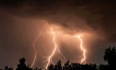
Additional risks include isolated instances of lightning strikes, hail and strong gusts of wind associated with the most active storm cells. While these impacts are not expected to be widespread, they may contribute to short-term disruption where storms are most intense during the warning window.
Warm Conditions and Shifting Weather Pattern across Northern England
According to the Met Office outlook, Friday across North Yorkshire will remain very warm, with maximum temperatures forecast to reach 34C. The air mass is expected to remain humid, contributing to a sense of heat under hazy sunshine, though cloud cover and thundery showers will interrupt brighter periods throughout the day.
Winds are expected to be mainly light outside of showers, although gusty conditions may develop locally within heavier rainfall. The timing of showers remains a key feature, with more active weather expected early and late on Friday as the main area of instability moves through the region during the morning hours.
The broader pattern suggests a sequence of showery and thundery outbreaks progressing eastwards across northern England over the weekend. While Saturday is expected to retain warm and hazy conditions, the overall trend points towards a gradual easing of heat intensity.
By Sunday and into Monday, temperatures are expected to move closer to seasonal averages as fresher air becomes more established. This marks a shift away from the peak warmth seen earlier in the week, replaced by more variable but less extreme conditions across the region.