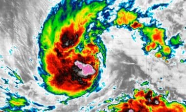
The storm developed quickly, moving from Invest 97L to Potential Tropical Cyclone Five, Tropical Depression Five and then Tropical Storm Edouard in less than 24 hours. Its arrival comes with forecasts for intense rainfall across parts of Texas and Louisiana, where emergency crews and local officials have already begun preparations.
Edouard Strengthens as Landfall Approaches
According to the National Hurricane Center, Edouard had maximum sustained winds of 40 mph in the 8 p.m. ET advisory and was moving west-northwest at 6 mph. The Associated Press reported that the storm was centered Monday evening about 140 miles southeast of Cameron, Louisiana, and 175 miles southeast of Port Arthur, Texas.
Forecasters expect Edouard to continue strengthening before reaching the coast on Tuesday. FOX Weather reported that landfall could occur as early as 1 p.m. to 3 p.m. ET, while forecasts cited in the television report indicated that the storm could have winds near 60 mph when it comes ashore.
A Tropical Storm Warning remains in effect from Port Bolivar, Texas, to the Vermilion-Cameron Parish line in Louisiana. Tropical-storm-force winds are expected to begin along the northeastern Texas and southwestern Louisiana coast Tuesday morning.
The storm’s relatively small circulation is also being closely watched because smaller tropical systems can intensify quickly. Communities including Beaumont, Port Arthur, Orange and Lake Charles were identified in the television forecast as being within the area at risk from the storm. Storm Surge Watches are also in effect for parts of coastal southwestern Louisiana. FOX Weather reported that areas near Port Arthur could experience storm surge of 2 to 4 feet.
Heavy Rainfall Raises Flash Flooding Concerns
Rain is expected to be one of Edouard’s main hazards. The Houston metropolitan area could receive 3 to 5 inches of rain as the storm moves inland slowly on Tuesday, according to FOX Weather.
The Associated Press reported a broader forecast of 3 to 6 inches across the greater Houston area, with parts of the upper Texas coast potentially receiving as much as 9 inches. Rainfall rates above 4 inches per hour could occur and are expected to produce flash flooding in low-lying and urban locations.
Another forecast cited the possibility of totals reaching 15 inches in some areas, with rainfall rates of 3 to 4 inches per hour as Edouard approaches and strengthens. Heavy downpours had already moved onshore in Harris County near Houston before the storm’s center reached the coast.
Texas officials said flooding was expected to be the primary concern. Gov. Greg Abbott said boats, helicopters and swift-water rescue crews had been positioned ahead of the storm, while some schools canceled classes for Tuesday. “This is our first big storm of the season, and I’ll tell you, Texas is prepared,” Orlando Alanis of the Texas Division of Emergency Management said during a news conference. Rain associated with Edouard is expected to remain a concern through Wednesday across parts of eastern Texas, including the Houston metropolitan area.