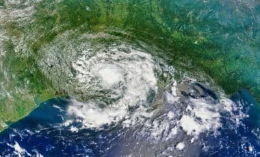
A major severe weather outbreak could unfold across parts of the Plains and Upper Midwest beginning Sunday, with tornadoes, destructive winds, large hail, and flooding rain all possible through early next week. Forecasters say the greatest concern is centered on Sunday and Monday, when multiple rounds of severe thunderstorms may develop from Texas to the Great Lakes region.
The National Weather Service’s Storm Prediction Center has warned that conditions may support strong tornadoes in parts of the Central Plains and Upper Midwest by late Sunday and again on Monday evening. According to forecasts cited by weather officials, the threat could intensify further as the system develops over the next several days.
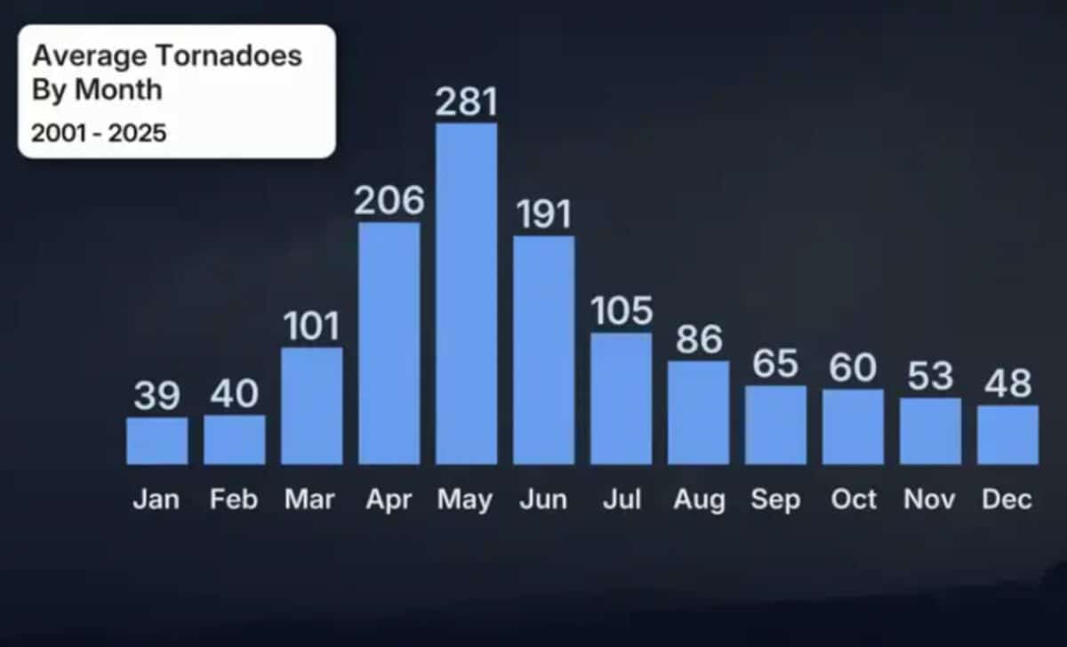
The severe weather setup follows a relatively quiet start to May for tornado activity across the United States, despite the month historically producing the highest average number of tornadoes each year.
Severe Thunderstorms Expected to Intensify Sunday and Monday
Storm activity is already expected to begin late Saturday into early Sunday across parts of the Midwest and Plains. Scattered supercell thunderstorms may develop near a frontal boundary, a dryline, and an area of low pressure, creating conditions favorable for severe weather.
Cities including Des Moines, Omaha, Lincoln, Sioux Falls, Chicago, and Indianapolis are among the locations identified within the risk zone for Saturday night. According to forecasts from the Storm Prediction Center, these storms could produce very large hail, wind gusts exceeding 75 mph, and a few strong tornadoes.
Sunday is expected to bring the first widespread phase of the outbreak. The highest risk area extends across portions of the Central Plains and Upper Midwest, where severe thunderstorms may occur in several rounds from morning through nighttime hours.
Meteorologists with NOAA’s Storm Prediction Center stated that strong tornadoes are possible by Sunday evening, particularly across the Central Plains. Areas farther south, including parts of Oklahoma, may experience fewer storms overall. Still, forecasters noted that any isolated storms forming along the dryline could quickly become supercells capable of producing hail, damaging winds, and tornadoes.
Monday may become the most active day of the outbreak. The severe weather zone could stretch from Texas northward into Michigan, with the greatest concentration of threats focused around cities such as Wichita, Omaha, Kansas City, and Des Moines.
According to NOAA’s latest outlook, strong to intense tornadoes, giant hail, destructive winds, and flooding rainfall are all possible Monday into Monday night. The Storm Prediction Center also indicated there may be a need to upgrade the threat level as confidence in the forecast increases.
Quiet Start to May Gives Way to More Active Pattern
The expected outbreak comes after an unusually calm first half of May for tornado activity across the country. Although May typically records the highest average monthly tornado count in the United States, storm reports remained limited during the opening weeks of the month.
According to NOAA and the National Weather Service, only a small cluster of confirmed tornadoes in southern Mississippi on May 6 stood out during the first half of May. Forecast data showed relatively sparse tornado reports elsewhere across the country through May 14.
Weather officials attributed the quieter pattern to cooler-than-average temperatures across much of the eastern and central United States, combined with above-average warmth in the West. Forecasters explained that this pattern differed from the typical late-spring setup associated with widespread severe weather east of the Rockies.
Storm activity has already begun to increase in recent days. Reports from May 14 and 15 included dozens of damaging wind and hail incidents across the Central Plains. According to storm reports referenced by forecasters, one wind gust reached 84 mph in Seagraves, Texas, while parts of Iowa recorded hail measuring up to 2.5 inches in diameter.
Severe thunderstorm risks are also expected to continue beyond Monday. Forecasts indicate additional storms may develop Tuesday across parts of the Southern Plains, the Mississippi Valley, and the Ohio Valley, with scattered severe weather remaining possible into Wednesday and Thursday across parts of the South and East.