
The weather in the UK looks set to turn for the worse as the temperature is expected to plummet before returning to warmer conditions. According to the weather forecast, a cold snap will hit the country on 26 April, with temperatures dropping as low as -1°C.
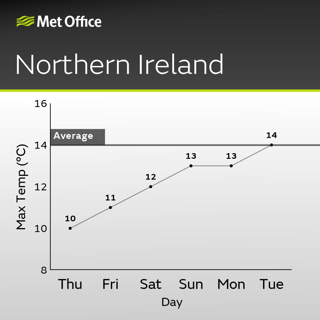
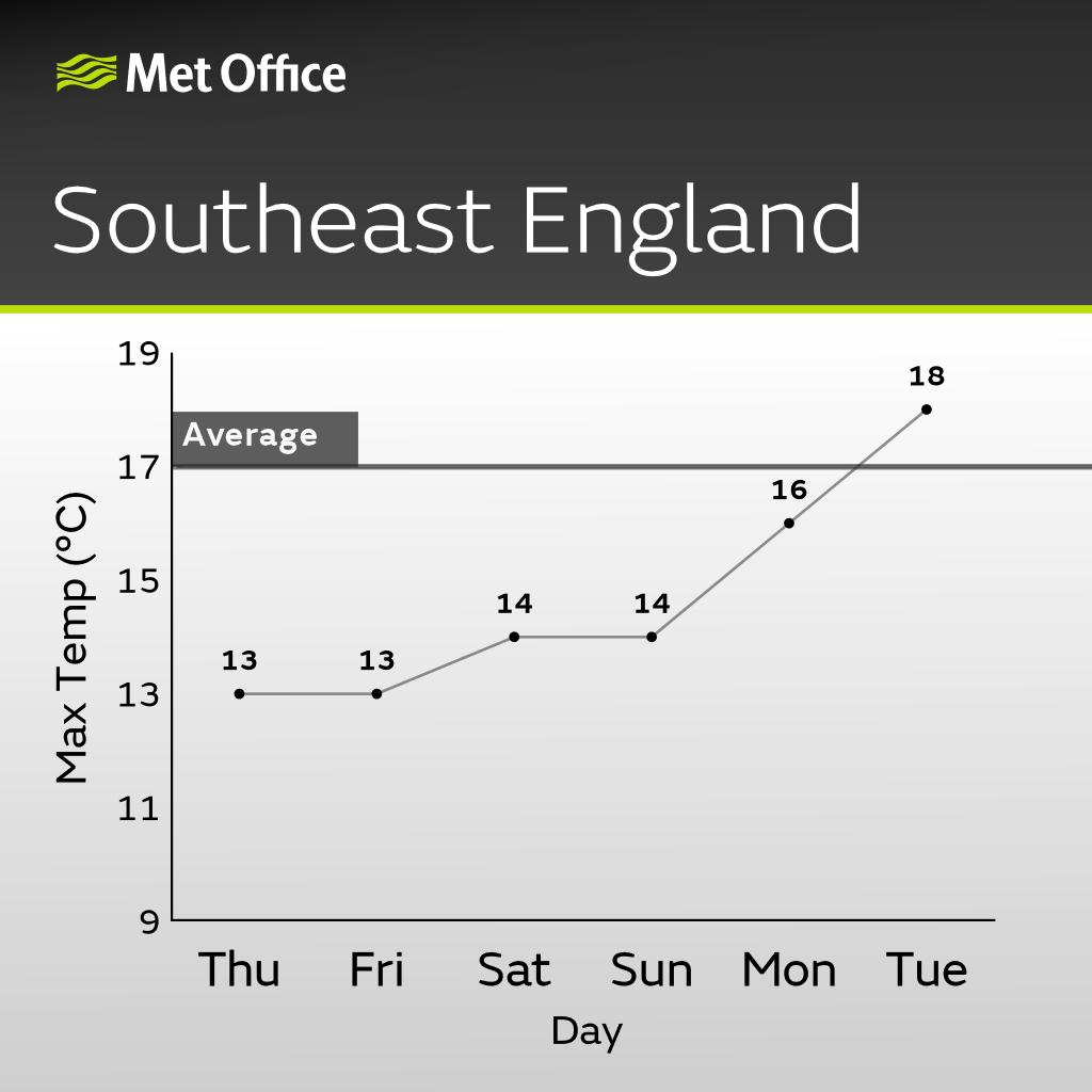
On Tuesday, south Wales experienced the warmest conditions, with temperatures in excess of 15°C at Mumbles Head. By contrast, the Highlands of Scotland experienced freezing temperatures.
But, as Ellie Glaisyer, meteorologist at the Met Office, pointed out, there was ‘nothing exceptional about these weather conditions, just a little below average for this time of year’.
Despite Tuesday’s warm weather, northern parts of the UK could see some light snow showers, according to WXCharts. The Metdesk data shows that areas around Inverness are turning a frosty purple on the maps, indicating possible snow accumulation.
“After another early touch of frost in places, it will be a sunny start for some, but clouds will build again to produce scattered showers.” Terry Scholey, Weather Analyst.
However, the freezing conditions are likely to be short-lived, with a warm front arriving over the weekend.
The Met Office has pointed out the role of a high-pressure system in the west of the UK, bringing northerly winds sweeping across the country. These arctic winds are the reason for the cooler-than-average temperatures, particularly in the eastern regions.
Warmer Weather on the Horizon
Fortunately, with the cold Arctic air receding, northern regions such as West Yorkshire, South Yorkshire and Tyne and Wear should expect a return to more seasonal temperatures, perhaps even a degree or two above average for the end of April.
Over the weekend, the north of England is likely to experience a ‘mini heatwave’, similar to the one that occurred earlier this month. This pleasant weather is expected to affect Yorkshire, the north-east of England and parts of eastern Scotland.
However, unlike the north, which is set to enjoy warmer weather, the southern regions of the UK are not so lucky. Heavy rain and possible thunderstorms are forecast, in stark contrast to the more pleasant conditions in the north.
Met Office 5-Day Weather Forecast
Today, the weather looks mixed depending on the region, with a cold but often sunny conditions. The sunny spells will be interrupted by scattered showers, potentially heavy, and a risk of wintry conditions over the northern hills. The cold will be particularly noticeable in the north and east.
- Evening and Tonight
Most showers will subside by the evening, but a few may still occur in the east. Cloudiness variable during the night, but becoming cool when there is clearing.
Another cool and rather cloudy afternoon is in prospect with scattered showers, these locally prolonged and heavy in the south 🌦️
Brighter interludes are possible with the best of the drier and sunnier weather in northern England and Scotland 🌤️
Winds staying light 🌬️ pic.twitter.com/5npLXphN0J
— Met Office (@metoffice) April 25, 2024
- Friday
Friday will kick off as it has today, with another chilly morning. Persistent showers will persist in the north and east, possibly accompanied by sleet and snow on the higher ground. Later in the day, rain will make an appearance in the south-west. Despite light winds, the cold will persist.
- Saturday to Monday
Looking ahead to the weekend, conditions are set to become increasingly unstable. Downpours will become more frequent, with periods of heavy rain and even thunderstorms.
Cloud cover will dominate the skies and strong winds will add to the cold. Nevertheless, temperatures will recover slightly from Sunday onwards.