
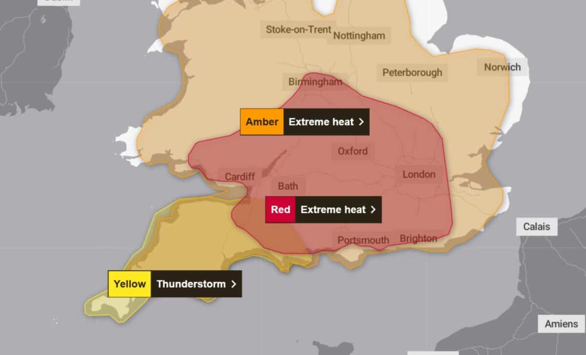
The Met Office has issued a yellow thunderstorm warning covering parts of south-west England from 6pm on Thursday, 25 June. According to the Met Office, scattered showers and thunderstorms are expected to move into the region after another very hot day, bringing the potential for localised disruption.
The warning applies to Cornwall, Devon, Dorset, Plymouth, Somerset and Torbay. The Met Office said that many places are likely to avoid thunderstorms altogether, although those that are affected could see sudden gusts of between 50 and 60mph, frequent lightning, hail and heavy rain. According to the Met Office, the greatest likelihood of impacts is along the south coast of Devon and Cornwall.
Thunderstorm Warning Follows Exceptional June Heat
The thunderstorm warning comes as the UK continues to experience unusually high temperatures during late June. According to the Met Office, the current conditions are exceptional for the time of year, with temperature records expected to be challenged during the week.
Met Office Chief Forecaster Matthew Lehnert said the combination of high daytime temperatures, elevated humidity and unusually warm nights increases the likelihood of significant impacts. He said that humidity would make conditions feel more intense for many people, while overnight temperatures remaining above 20°C across large parts of England and Wales would add to the effects of the heat.
Lehnert also noted that red weather warnings are reserved for the most severe events, adding that the expected impacts from the heatwave include health issues extending beyond those who are generally considered most vulnerable to high temperatures.
Heavy Rain Expected to Spread beyond South-West England
The wider weather pattern is expected to become increasingly unsettled as the week progresses. According to BBC Weather, Thursday will remain sunny and hot across much of the country, although areas along North Sea coasts may see local fog and northern regions could experience patchy cloud. Rain is also forecast in the far north-west, bringing a risk of thunderstorms.
BBC Weather said outbreaks of heavy rain across Scotland are expected to move south-eastwards, with torrential downpours and a risk of lightning in some places. Thundery showers are also forecast to develop across south-west England before moving inland during Thursday evening.
Looking ahead to Friday, BBC Weather reported that heavy, thundery rain is likely to linger across parts of north-eastern England and eastern Scotland during the morning before becoming more widespread across Scotland later in the day. Conditions further south are expected to remain drier.
The outlook for Saturday through Monday indicates a gradual change in weather conditions. According to BBC Weather, Saturday is expected to be breezy with showers across northern areas, while southern parts should see sunny spells with the chance of isolated showers. Westerly winds are forecast to bring patchy cloud and lighter showers on Sunday, with drier conditions in eastern areas and temperatures becoming less warm. On Monday, rain is expected across northern parts of the UK, while southern areas should see variable cloud and sunny spells before conditions turn dry and sunny later in the evening.