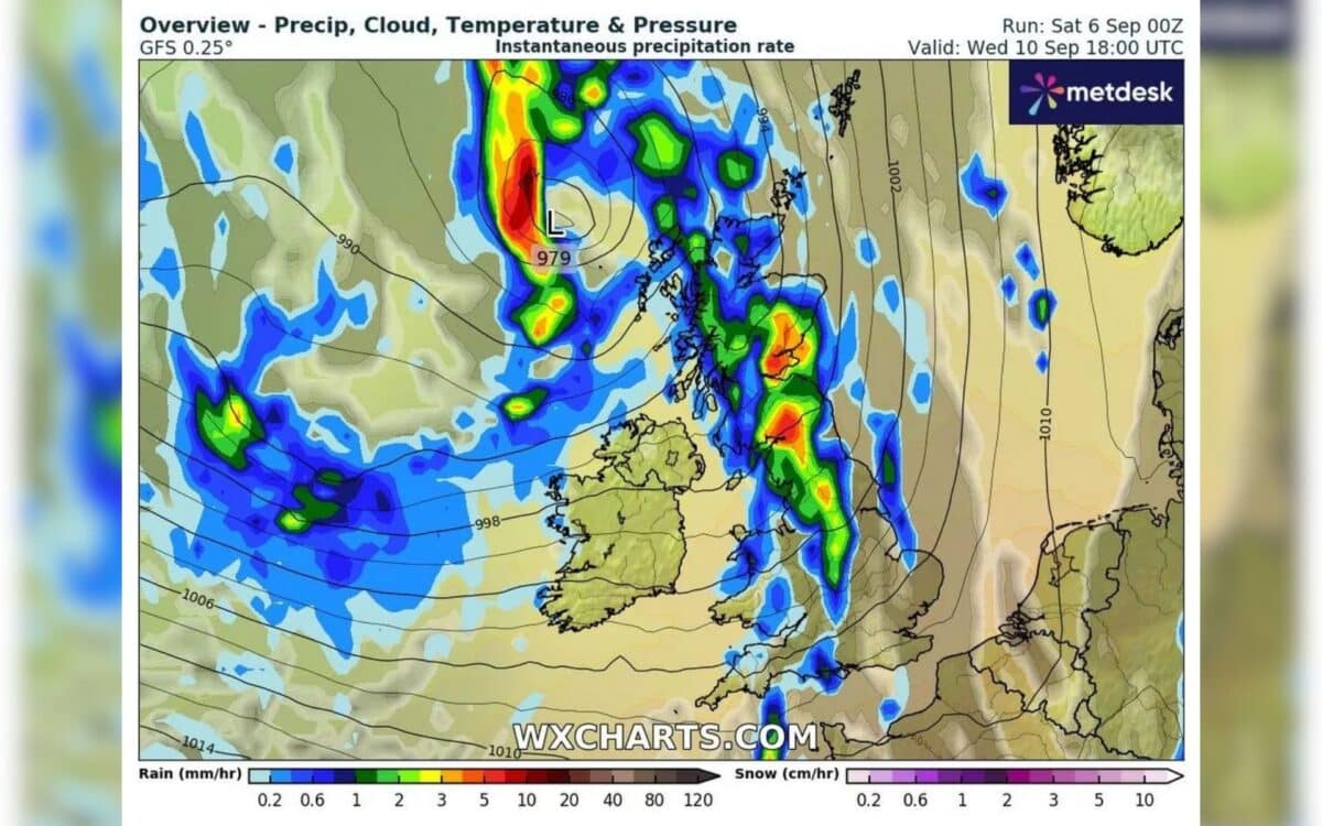
A major weather shift is set to hit the UK on Wednesday, September 13, as the Met Office and other forecasters warn of a widespread deluge that will end the recent run of sunshine. According to data from WXCharts, based on MetDesk models, a large rain system is expected to move in from the west and spread across much of the country during the day.
The Met Office has issued guidance describing the period as “unsettled,” pointing to heavy rain, strong winds, and the possibility of hail. Reports highlighted by the Mirror note that showers are likely to be widespread, with rainfall intensifying into the evening.
Rain Starts Early in Scotland and Isle of Wight
Showers are expected to begin as early as 6am, first striking the west coast of Scotland, including Galloway Forest Park, the Outer Hebrides, and up to Achmelvich. By 9am, the rain will have moved further inland while a separate patch is forecast to affect the Isle of Wight on the south coast. Early rainfall rates will remain modest, around 0.6 mm per hour.
Intensifying Through the Afternoon
By 3pm, rainfall will become more intense, with bursts of around 3 mm per hour hitting Wales and Scotland. Between 3pm and 9pm, forecasters expect hourly rates to reach 5 mm, leading to totals of 30 mm, or approximately 1.18 inches of rain over several hours.
The Met Office warned that
Showers or longer spells of rain will affect most of the UK at times. Some heavy rain or showers are expected in places, most often in the west and north. Thunderstorms and hail are also possible, as are some spells of strong winds, especially if any deep areas of low pressure develop and affect the UK.
Widespread Evening Downpours
By 6pm, showers will cover England, Scotland, and Wales, with the heaviest rain falling in Birmingham and Manchester. Northern England is expected to be hit particularly hard, with downpours in the Yorkshire Dales National Park and the North Pennines National Landscape.
In Scotland, Edinburgh is among the areas forecast to experience some of the most severe showers. By around 9pm, the main system will move off the east coast, though unsettled conditions are expected to linger.
Met Office Outlook for the Rest of the Week
The Met Office long-range forecast points to a continuation of unsettled weather after September 13. It states:
This period is likely to start out unsettled, with low pressure dominating the pattern. This will mean showers or longer spells of rain will affect most of the UK at times.
The forecast adds that deep low-pressure systems could drive “spells of strong winds,” particularly in the west and north.
Looking ahead, the Met Office also highlights the possibility of “longer spells of drier weather” developing toward the south, with more sunshine if high pressure strengthens. Temperatures are expected to remain close to or just below seasonal averages, but the agency notes they “may rise above at times in any drier, sunnier spells.”