After a summer already marked by four heatwaves and soaring mercury levels, early September is now shaping up to deliver a fifth blast of intense heat, according to early indications from the Met Office. Weather maps are turning red once more, with 30°C temperatures likely to return in parts of the UK. The potential spike comes as meteorological models indicate a shift in atmospheric pressure patterns across Europe.
Mid-range projections suggest that certain regions—particularly in eastern England—could experience a temporary rise in temperatures. According to The Mirror, the Met Office has acknowledged the possibility of short-lived warm spells, though it has so far issued limited detail on timing or intensity.
Fifth Heatwave Possible as High Pressure Builds Over Europe
As the UK emerges from a stretch of cooler, unsettled weather, meteorologists are now tracking a developing high pressure system over the European continent. This system is expected to shift northeast, potentially delivering a surge of warmth into eastern England by the 8th of September.
Forecasts currently show the 30°C mark could be reached in regions such as East Anglia, Hull, and areas stretching into the north west, where temperatures may climb into the mid 20s°C.
This could mark the UK’s fifth heatwave of the summer, adding to a string of record-breaking hot spells. The previous four waves brought with them heat-related health alerts, pressure on water supplies, and elevated fire risks in dry regions.
Eastern England to Bake While West and Scotland Stay Cooler
The heat will not be felt evenly. While eastern counties could see temperatures peaking at 30°C, western regions, including Wales and southwest England, are unlikely to rise above 20°C, according to current models.
Scotland is expected to remain relatively cool on September 8, but conditions may warm slightly by September 9, with temperatures climbing higher than the previous day, particularly in southern and central areas.
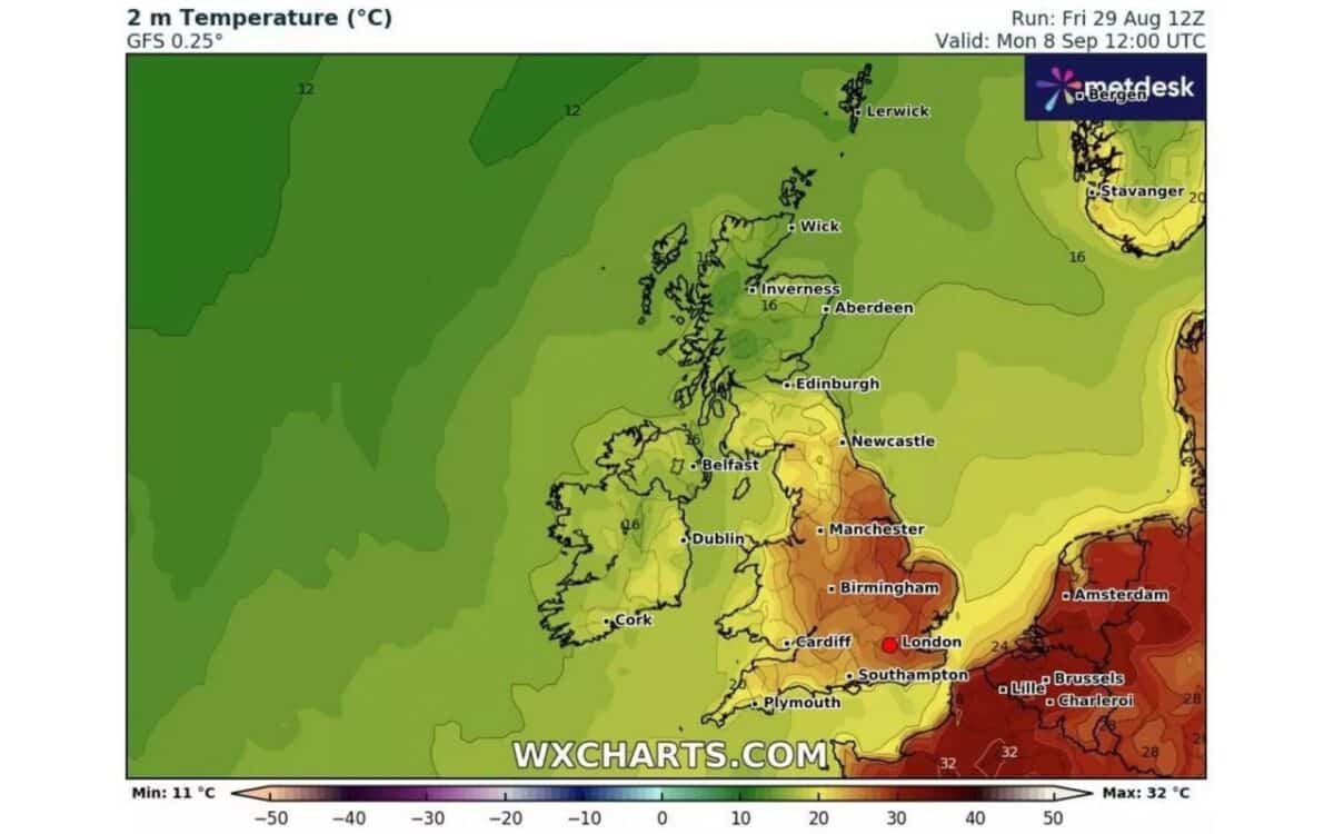
The Met Office expects the warmest conditions to remain localised to the east:
The highest temperatures could reach as far north as Hull and across into the north west of England it could also be in the mid 20Cs, but in most of Wales and southwest England it is unlikely to get higher than 20Cs.
September 9 to Bring Narrower Heat Zone, Mild Lift in Scotland
On September 9, the red zone on weather maps appears more concentrated, staying tightly over eastern England. While 30°C could still be reached locally, the heat coverage shrinks compared to the previous day.
Meanwhile, Scotland is expected to warm up, with temperatures likely pushing closer to average seasonal highs, and some areas enjoying dry and sunnier spells. This transition marks a northward extension of warmth, previously confined to southern parts of the UK.
Official Forecast Confirms Unsettled Pattern With Brief Warm Interludes
From September 3 to 12, the Met Office anticipates a changeable weather pattern, as low pressure continues to influence conditions across much of the country.
In its forecast bulletin, the Met Office states:
Changeable and unsettled weather conditions are expected across the UK during this period, with low pressure systems tending to dominate the overall pattern. This will mean showers or longer spells of rain will affect much of the UK at times.
The agency adds:
Some heavy rain or showers are expected in places, most often in the west. Thunderstorms and hail are also possible, as are some spells of strong winds if any deep areas of low pressure form in the vicinity of the UK.
But it’s not all gloom. The forecast also notes:
Some short-lived spells of drier and more settled weather are also possible at times, especially later in the period when they may last a little longer. Temperatures will likely be close to average or slightly below overall, but may rise above at times in any drier, sunnier spells.