A new tropical cyclone is forming off Australia’s north-east coast, raising concerns of another major weather event in a region still recovering from recent damage. Authorities are closely monitoring its path as uncertainty remains high. If forecasts hold, parts of Far North Queensland could be hit within days. The situation is evolving quickly.
A Category 3 Cyclone Already Under Close Watch
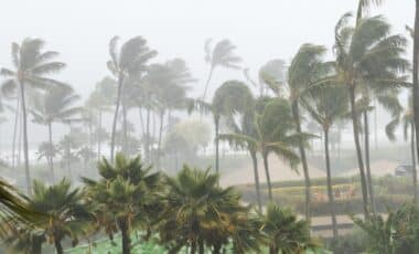
Australia’s Bureau of Meteorology is currently tracking Tropical Cyclone Maila, a system already classified as category 3. It is producing sustained winds of around 120 km/h, with gusts reaching up to 165 km/h, levels capable of causing structural damage and widespread disruption.
Maila is moving slowly through the Solomon Sea, a detail that complicates forecasts. Slow systems tend to be harder to predict, sometimes lingering, sometimes shifting unexpectedly. Current modelling suggests a south-west trajectory, with a possible landfall along the Far North Queensland coast by the weekend.
That said, confidence in the exact path remains limited. A slight deviation offshore could reduce direct damage. A shift inland, on the other hand, would change the situation entirely. Forecasting, in this case, feels a bit like trying to pin down something that keeps moving just out of reach.
Communities Still Recovering from Cyclone Narelle
The timing is particularly sensitive. Just weeks ago, Cyclone Narelle swept across northern Australia, impacting Queensland, the Northern Territory and Western Australia. The storm brought flooding, strong winds and infrastructure damage, leaving some communities still in recovery mode.
This context matters. Ground saturation remains high in certain areas, increasing the risk of renewed flooding if Maila follows a similar path. It’s not just about wind strength this time — accumulation of rainfall could become the main concern.
There’s also a quieter factor at play: fatigue. Preparing once is routine in cyclone-prone regions. Preparing twice in quick succession is something else entirely. Some residents have barely finished repairs.
An Active Cyclone Season Nearing Its End
The current cyclone season, which officially runs until the end of the month, has been notably active. Maila is the 11th named system to form in or enter the Australian region this season.
Forecast models indicate the cyclone could maintain — or even strengthen — its intensity over the coming days. One scenario suggests a crossing over the Cape York Peninsula, followed by a temporary weakening over land, then a possible reintensification in the Gulf of Carpentaria.
This type of track, shifting between land and warm waters, is not unusual. Still, it introduces layers of uncertainty, especially for regions that may be affected later in the system’s path.
Wider Regions on Alert as Uncertainty Persists
Attention is also turning toward the Top End, where a weakened or reorganised system could bring heavy rainfall early next week. At this stage, forecasters remain cautious about any potential extension toward Western Australia, though it has not been ruled out.
Authorities are urging residents to stay updated with official forecasts and prepare as needed. No immediate emergency measures have been announced, but the situation is evolving.
In northern Australia, cyclone season rarely ends quietly. This time, the question is simple: how many regions will be affected before it finally settles down.