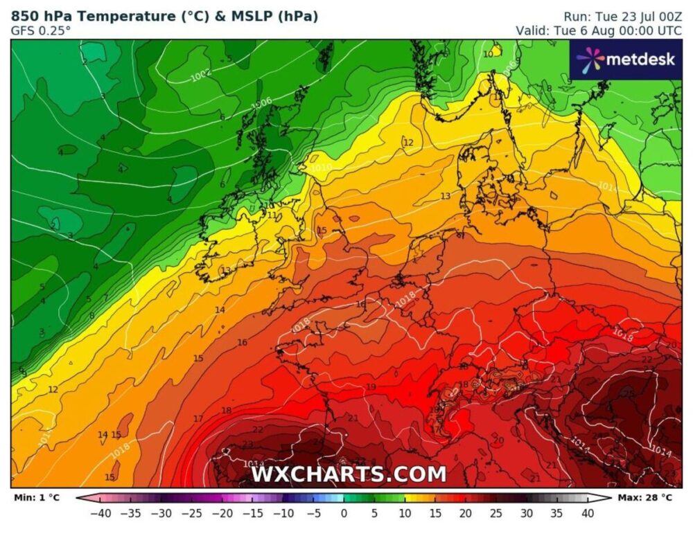
New weather maps show that some parts of Britain could experience very hot temperatures in the next few days, as a 224-mile-wide heat dome from Europe is heading towards the UK.
The UK will witness another heatwave after it observed its hottest day of the year on Friday, with temperatures near St James’s Park in London reaching almost 32 °C.
A mostly dry and bright start for many 🌤️
Showers across central England during the morning 🌦️
Cloud starts to move in from the west by midday pic.twitter.com/4JE5K13MY3
— Met Office (@metoffice) July 23, 2024
Forecasted Temperature for Various Regions of the UK
- Southern England: Temperatures are expected to reach 20 degrees, with London and parts of the south-east reaching up to 27 °C by Monday, August 5.
- Central England: Areas from Southampton to Manchester will see temperatures in the mid-20s.
- Wales: Expected to experience temperatures in the upper teens.
- Scotland: Glasgow and Edinburgh will see around 17 °C, while other parts of Scotland will be cooler, with lows of 12 °C.
Ian Simpson, an analyst at Netweather, stated that long-term mean temperature values for 1991-2020 would not be far off in north-west Scotland while England has chances of going up to +1.5C above the normal line (especially in the east).
Rainfall and Sunshine
- North-west Scotland: Wetter conditions are anticipated.
- Rest of the UK: Drier than normal, particularly in England, Wales, and south-east Scotland.
- Sunshine: Above normal in most parts of England, Wales, and eastern Scotland. Western Scotland and Northern Ireland will have near or slightly below normal sunshine.
Ian Simpson says that the high pressure from the Azores will bring frequent rain belts into western and northern Scotland, but these will be much rarer across central/southern/eastern England.
Simpson indicated there was a possibility of some very hot air briefly coming towards the south-east around July 31 with a chance of reaching the mid-thirties, though this may also result in heat over the English Channel as well.
Week’s End Outlook
The week onwards might see warm and sticky weather settle in, especially towards the end of the week. Persistent rain could occur over western Scotland with cloudy skies at times in the west of Britain, while sheltered eastern counties may see more sunshine.
Met Office Weather Predictions
From July 28 into early August, the Met Office forecasts:
- Fine and Dry Weather: Predominantly fine and dry weather across the UK on Sunday, with temperatures close to or slightly above normal.
- Changeable Pattern: The following week will likely see a mix of showers, longer spells of rain, and dry, bright intervals. The wettest conditions are expected in northern and western areas, with the south and east remaining drier.
- Temperature Outlook: Temperatures will probably be close to or slightly above average during this period, with some outbreaks of heavy rain or thunderstorms possible.


