Newly published weather maps indicate that the UK could experience a three-day heatwave later this month, marking the potential start of summer.
Potential Three-Day Heatwave Predicted
According to the latest forecasts, Britain is set to experience temperatures of up to 27°C around London on Sunday 23 June.
This heatwave is not confined to the south; even the most northerly parts of Scotland could see temperatures rise to 22°C on the same day.
Temperatures are forecast to approach 25°C on Sunday 23 June on the north-east coast, including areas near Newcastle, as well as around York and Harrogate.
However, the heat is expected to ease slightly the following day, with maximum temperatures of around 24°C in the London area and near Lincoln.
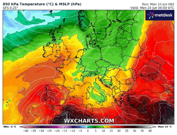
On Tuesday 25 June, the three-day hot spell is expected to come to an abrupt end, with temperatures across Britain dropping to between 9°C and 16°C.
Jim Dale, Chief Meteorologist for the UK Meteorological Services, attributes the heatwave to a flow of air from Spain and France.
He comments: ‘If it materialises, it looks like a short transfusion of very warm and somewhat humid weather before the approach of an Atlantic frontal system. So we’re talking about a southerly airflow from Spain and France.
Mr Dale added: ‘Expect widespread temperatures of 20-22°C, with highs of 25-26°C in south-east England and the Moray Firth region’.
However, he warned against over-optimism: ‘Don’t hold your breath; it hasn’t happened yet and, if it does, it’s unlikely to last’.
The Met Office’s long-term weather forecast, which covers the period from Saturday 15 June to Monday 24 June, indicates that overall temperatures will be ‘below average’ for this time of year.
5-Day Weather Forecast
The weather in the UK is mixed today. Many areas remain cloudy, but there were some sunny spells, particularly in the west of the country.
Showers easing and becoming confined to the east this evening 🌦️
Largely dry elsewhere with clear spells developing, mostly in the west ☁️ pic.twitter.com/CKBK66jn7D
— Met Office (@metoffice) June 11, 2024
Evening and Overnight:
- Most areas will see the showers diminish this evening.
- A few may continue along the north and east coasts into the early hours.
- Most places will be dry tonight and clear spells will develop.
- Once again, it will be cold with the possibility of scattered frosts.
- Temperatures will remain around 9°C or 10°C.
- In regions enjoying clear spells, temperatures may fall to 3°C or 4°C in sheltered areas.
Wednesday:
- Tomorrow will be another bright and rather cool day for this time of year, with temperatures of around 17°C or 18°C.
- Clear skies and scattered showers, although the showers will be concentrated mainly in the east.
Outlook for Thursday to Saturday:
- Showers moving north-easterly over the UK on Thursday, accompanied by strong winds.
- Sunshine and heavy thundery showers on Friday and Saturday.
- The weather will remain cool and windy.
Detailed regional forecasts
Scotland and Northern Ireland
- Central and Western Scotland: Blue skies and dry conditions prevail, especially in the morning.
- East of Scotland: Scattered showers possible during the day.
- Northern Ireland: Similar to Scotland, with dry, sunny spells.
England
- Northern England: Cloudy with occasional showers, particularly in coastal areas.
- Midlands: Mostly cloudy with a few sunny spells.
- South of England: A mixture of cloud and sunshine, with the south-west being the sunniest.
Wales
- West Wales: Likely sunny spells and drier conditions.
- East Wales: Cloud cover with the possibility of scattered showers.

