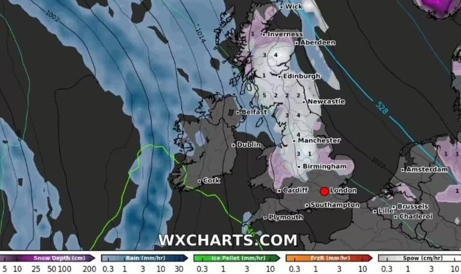
A powerful snowstorm is set to sweep across England and Scotland, with 19 cities expected to experience wintry conditions by midnight on Monday, February 17, according to Birmingham Mail and Express. The latest weather maps from WXCharts, based on Met Desk data, reveal that a 500-mile-wide snow band will stretch from the Scottish Highlands down to the Midlands, bringing accumulations of 1 cm to 5 cm in several regions.
Snowfall Expected Across Major Cities
The approaching cold front will bring significant snowfall to multiple cities, particularly in Scotland, northern England, and the Midlands. The most affected areas include:
- Scotland: Aberdeen, Dundee, Edinburgh, Glasgow
- Northern England: Carlisle, Newcastle, Sunderland, York, Leeds, Bradford, Sheffield, Preston, Manchester
- Midlands: Stoke-on-Trent, Liverpool, Lincoln, Nottingham, Leicester, Derby
Heavier snowfall is likely in higher-altitude areas, with urban centers seeing lighter accumulations that could melt quickly.
Cold Health Alerts Issued for Vulnerable Regions
Authorities have issued cold health alerts due to the anticipated temperature drop. The UK Health Security Agency (UKHSA) has placed North East England and Yorkshire & Humber under yellow health warnings, effective from Friday, February 14, at 9 PM until Tuesday, February 18, at 9 AM, according to Birmingham Mail.
Despite concerns over freezing conditions, the Met Office has not issued any severe weather warnings. Meteorologists continue to monitor conditions closely for any necessary updates.
Snowfall Impact on Travel and Infrastructure
Severe disruptions to road and rail networks are expected across the affected regions. Icy roads and poor visibility will make travel hazardous, particularly on untreated routes and higher-elevation highways. Drivers are urged to use caution, allow extra time, and check road updates before setting out.
Transportation delays could also extend to rail networks, especially in Scotland and northern England, where snow-covered tracks may force trains to operate at reduced speeds. Airports in Manchester, Newcastle, and Edinburgh may experience flight delays or cancellations if snowfall intensifies, according to Express.
Met Office Weather Forecast for the Coming Days
Meteorologists predict a cold and unsettled pattern throughout the week. The Met Office’s five-day forecast, cited by both Birmingham Mail and Express, outlines the expected conditions across the UK:
- Sunday, February 16 – Predominantly cloudy, with rain and wintry showers in Scotland and northern England. Breezy conditions will make temperatures feel even colder.
- Monday, February 17 – The peak of the snowfall, affecting 19 cities. Rain showers may mix with snow in some low-lying areas.
- Tuesday to Thursday – Gradual clearing of snow in southern regions, though northern areas will continue to see hill snow and icy patches. Temperatures will begin to rise slowly, but frost and slippery conditions may persist during the mornings.
How to Prepare for the Cold Conditions
With freezing temperatures and icy surfaces becoming widespread, authorities are urging residents to take precautions. The UKHSA advises:
- Wearing layered clothing to conserve body heat
- Keeping indoor temperatures at a minimum of 18°C
- Checking in on elderly neighbors and vulnerable individuals
- Allowing extra time for travel and staying updated with local weather alerts
Conditions are expected to stabilise midweek, though Scotland and northern England may experience patchy snow and lingering frost for several more days. Rising temperatures will gradually improve road conditions, but early morning ice and slippery surfaces could remain a concern.
Meteorologists recommend staying updated on official weather reports and taking necessary precautions to remain safe during this winter weather event.


