The situation is expected to disrupt daily life in numerous regions, as flood risks intensify over saturated ground. Emergency services, local authorities and weather agencies are actively monitoring conditions, while residents are being urged to stay informed and take precautionary steps.
Flooding Risk Intensifies with Amber and Yellow Warnings in Place
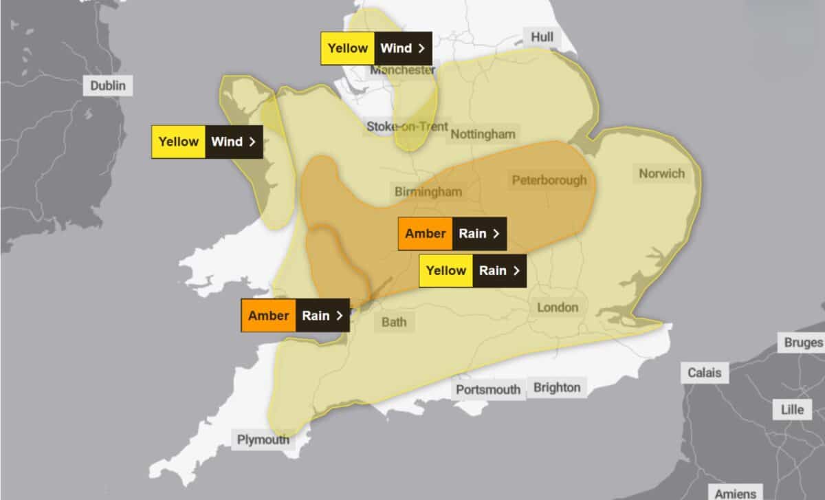
According to the Met Office, Storm Claudia is expected to bring “persistent and heavy” rainfall across central England and Wales, with accumulations of 40–60mm widely forecast. Localised peaks of 80mm or more are anticipated, especially over elevated terrain in the East Midlands, western England, and parts of Wales.
The amber warning—currently in effect across six West Midlands counties, indicates a higher likelihood of flooding and disruption, while the yellow warning, which extends from Cheshire and North Yorkshire to the South Coast, remains active for a full 24 hours from Friday morning.
The Environment Agency confirmed that surface water and river flooding are already being observed in parts of northern England. Ben Lukey, flood duty manager, stated: “Storm Claudia will bring heavy, prolonged rainfall across parts of England, with significant surface water flooding probable across parts of central England on Friday. River flooding impacts are also possible tomorrow and into Saturday.”
Emergency teams are currently clearing waterways and preparing flood defences. Meanwhile, Floods Minister Emma Hardy said she is in close communication with the Environment Agency and other local response teams to support affected communities: “I recognise people will be concerned about the risk to their homes and livelihoods.”
Wind and Travel Disruptions Expected across Southern and Western Areas
Alongside intense rainfall, strong easterly winds are forecast to accompany the storm. Gusts of 60–70 mph are possible in exposed parts of north-west England and north-west Wales, adding to the risk of treefall and infrastructure damage.
The Met Office also cautioned about slower travel conditions, road spray and standing water, with rail and road users urged to allow extra time. The AA has advised against unnecessary travel, warning that even shallow floodwater can cause vehicles to lose control. “Flood water can appear quickly, and even shallow water can be dangerous – never try to drive through it,” the organisation noted.
As the weather system approaches, Matthew Lehnert, Chief Meteorologist at the Met Office, remarked: “This rain will become slow-moving and some areas could see up to a month’s worth of rain in 24 hours. Much of this will fall on saturated ground, increasing the chances of flooding.”
Although Storm Claudia is not expected to pass directly over the UK, its proximity is sufficient to trigger significant atmospheric instability. The storm’s centre remains west of the British Isles, having already affected the Canary Islands earlier in the week.
Residents in affected areas are being urged to monitor live weather updates and follow flood safety guidance. The Met Office has outlined steps including checking flood risk maps, assembling emergency kits, and safeguarding valuables.
The Environment Agency has deployed field teams to monitor river levels and support local response measures, while power companies and councils remain on standby for emergency repairs. Storm Claudia is forecast to linger into the weekend, with drier but colder weather expected by Sunday, including overnight frost in some northern regions.


