The UK could face a challenging end to January, as weather forecasts predict a double onslaught of heavy snow and torrential rain. According to the Met Office and WXCharts, significant weather disruptions may unfold across the country, with northern England, Scotland, and Wales bearing the brunt of heavy snow, while the south-west grapples with relentless rainfall.
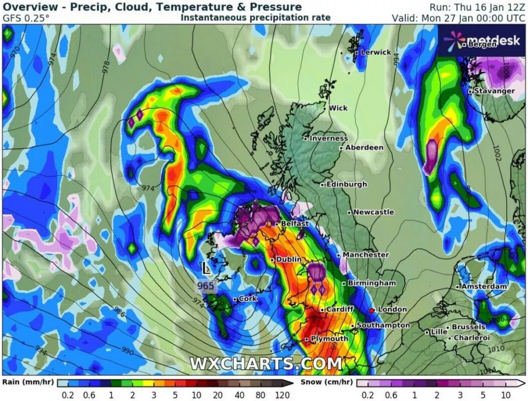
The latest weather models indicate a storm moving across the UK on January 26, bringing varied and extreme conditions. Torrential rain is expected in southern areas, while snow showers are likely to dominate the northern regions. With snowfall rates potentially reaching up to 10 cm per hour in places like the Lake District, travel and daily routines could face serious challenges.
A Grim Forecast: What the Weather Models Show
WXCharts‘ predictions paint a stark picture of January’s closing days. A powerful storm is set to arrive on the evening of January 26, impacting regions differently:
- South-west England could experience downpours of up to 10 mm per hour, leading to the potential for localized flooding.
- Northern Ireland and Wales are forecasted to see a mix of snow and rain, with snow falling at rates of 5 cm per hour in some areas.

The storm system is expected to intensify as it moves northward. By early January 27, snow is projected to cover much of northern England and Scotland, with urban centres such as Edinburgh, Glasgow, and Newcastle likely to be affected. Areas like the Lake District could see extreme snowfall, accumulating at 10 cm per hour.

A second burst of snow may return on January 30, targeting North Wales and parts of the Midlands. Snowfall in these regions could match the earlier intensity, causing further disruptions.
The Met Office’s Perspective
The Met Office’s long-term outlook underscores the unpredictability of this weather system. Their forecast for January 21–30 suggests a mix of relatively calm conditions early in the week, followed by much wetter and windier weather later.
Key points from their predictions include:
- A brief period of settled and colder south-Easterly winds, which may shift to bring snow showers.
- The likelihood of widespread rain and wind dominating the latter half of the month.
- Temperatures hovering around seasonal averages, with colder conditions in certain regions.
Short-term forecasts provide additional context:
- Today: Patchy rain in Scotland and Northern Ireland; dry but chilly in England.
- Saturday: Dry and cloudy for most, with milder temperatures in the north.
- Sunday to Tuesday: Chilly with intermittent rain, particularly in western regions.
What This Means for the UK
The anticipated snow and rain could disrupt travel, infrastructure, and daily life, especially in regions expecting heavy snowfall. Local authorities may need to prepare for potential flooding in the south-west and icy conditions in the north.
With forecasts indicating dynamic and unpredictable weather patterns, residents are urged to stay updated on regional alerts and take precautions as needed. The final week of January could test the resilience of communities across the UK.


