
The Met Office has issued a yellow wind warning ahead of a period of unsettled weather expected to affect wide areas of England and Wales over the coming days. The advisory covers both inland and coastal regions and will remain in effect from 8pm on Sunday through to 6pm on Monday, according to official forecasts.
A report by the Manchester Evening News indicates that northwestern areas could experience some of the highest gusts during this time. While the exact impact remains uncertain, the forecast is being closely monitored by meteorological services, as travel and public safety concerns are anticipated across affected zones.
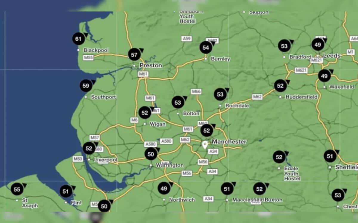
Met Office Warning Extended to Cover Most of England and Wales
The yellow warning will be in effect from 8pm on Sunday until 6pm on Monday, as a deep area of low pressure moves across the country. Initially covering southern areas, the warning was extended on Friday morning to include most of England and Wales, with a specific emphasis on northwestern regions such as Greater Manchester, Lancashire, and Merseyside.
Forecast models show widespread wind gusts between 45 and 55mph, with exposed coastal areas experiencing gusts up to 70mph. The highest speeds are expected on Monday morning, especially around 10am.
Blackpool, Southport and Preston Among Most Exposed Areas
The strongest gusts are forecast along the North West coast, with Blackpool expected to experience winds up to 61mph. Inland cities like Manchester and Liverpool may see gusts around 52–53mph. The top wind speeds currently forecast for the region include:
- Blackpool: 61mph
- Southport: 59mph
- Preston: 57mph
- Burnley: 54mph
- Rochdale, Bolton: 53mph
- Manchester, Liverpool, Wigan, Huddersfield: 52mph
- Chester, Warrington: 50mph
These gusts, while significant, are consistent with early meteorological autumn weather patterns and are not currently associated with any named storm.
Authorities Monitor Risk but Storm Not Currently Named
According to Graham Madge, spokesperson for the Met Office, there is no current plan to name the weather system responsible for the high winds. While the low-pressure system is likely to bring disruption, it remains within the expected range for seasonal weather in September.
“This is the sort of weather that we do expect at this time of year,” Madge explained, noting the contrast with milder summer weather may make conditions seem more extreme.
Transport Disruption Possible in Exposed Areas
The RAC has issued a statement advising motorists to plan their journeys carefully. Rod Dennis, spokesperson for the RAC, said that driving conditions will be challenging, particularly on exposed routes such as moorland roads and coastal highways.
“Drivers are really going to feel the effects of the early autumnal weather this weekend – he noted.”
The wind will be particularly noticeable on more exposed roads, like those over the moors in Devon and Cornwall, so drivers may like to delay their journeys or seek other routes.


