
Nearly half a month’s worth of rain is forecast to soak large parts of the UK over a four-day period, with the Met Office warning of persistent downpours, local flooding risks, and possible power disruptions. Forecast data outlines a sharp transition toward more unsettled conditions, beginning late Friday and continuing through to Tuesday.
The affected areas span a wide geographical range, with rainfall expected to intensify across several regions. This major shift in weather patterns marks a decisive end to the recent spell of mild, cloudy conditions, as a low-pressure system barrels in from the west, bringing widespread rainfall and gusty winds.
Heavy Rainfall and Flood Warnings Across Northern Ireland and the South
The Met Office has issued a yellow weather warning for rain over parts of Northern Ireland, particularly affecting areas around the Mourne Mountains. The agency warns:
Heavy rain will spread east throughout the day. Over the Mournes, 60–100 mm could build up, much of this falling in the early hours of Sunday morning.
Across the wider UK, up to 50mm of rainfall is expected to accumulate in the hardest-hit areas between Friday and Tuesday—roughly half the average monthly total for many regions. This figure is based on a four-day accumulation, including rain that already began Friday across western areas.
Visual data from Met Office rainfall maps show a deep blue hue over south Wales and parts of the Southwest of England, signaling these as high-risk zones, where sustained rainfall could trigger localized flooding and travel disruptions.
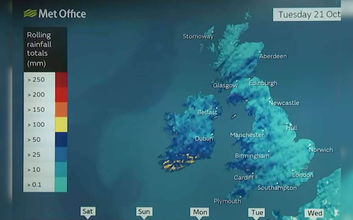
In Swansea, where October averages around 110mm of rain, and in Belfast, where the average is closer to 96mm, receiving 50mm in just a few days is highly significant. Even further north, cities like Birmingham—which typically see 80 to 90mm in October—are likely to feel the impact. This north-south spread emphasizes the widespread nature of the upcoming storm.
Public Advised To Prepare For Flooding and Potential Power Cuts
As water levels rise, residents are being urged by the Met Office to take precautionary steps. Those in flood-prone areas should check their property’s risk status and consider setting up a flood plan. The agency specifically advises preparing for potential power outages, noting:
In case power cuts occur, residents should also prepare some essential items including torches and batteries, a mobile phone power pack and other essential items.
While a yellow warning is currently active for Sunday morning in Northern Ireland, the Met Office confirms:
Currently, there are no more weather warnings in force over the coming days – That said,
the situation remains dynamic, and further alerts may be issued as the weather system progresses.

The Met Office’s official forecast for the period Sunday to Tuesday reads:
Unsettled and breezy, with rain spreading eastwards through Sunday, prolonged and heavy in places. Blustery showers from Monday, some thundery at first, a few sunny spells too. Temperatures near normal.
The language reflects both the persistence of rainfall and the potential for sudden, intense showers—particularly as the system moves eastward.
Thunderstorms Expected In Southwest And Midlands
Storm activity won’t be limited to Northern Ireland. According to a report from The Mirror, thunderstorms are likely on Monday, especially across the Southwest of England and the Midlands—including counties like Wiltshire, Gloucestershire, and Worcestershire.
These conditions could make for dangerous commutes and temporary power outages in some locations.
Though parts of the UK enjoyed unusually warm temperatures on Friday—reaching 18°C in Aberporth, Ceredigion, and 17.8°C in Plymouth, Devon—the outlook has now flipped. The advancing system brings a noticeable change not just in temperature but in overall atmospheric pressure and wind conditions. The Met Office continues to monitor the evolving patterns closely.


