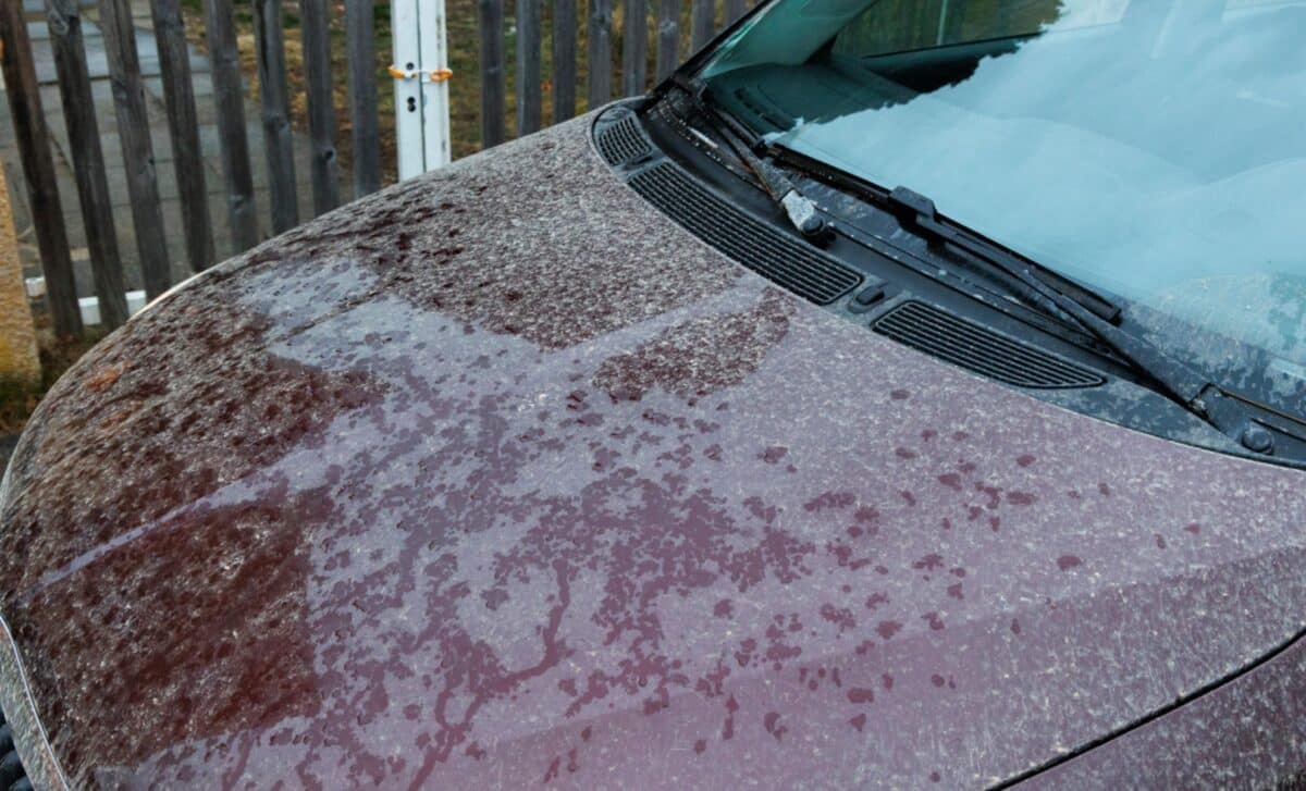
A plume of Saharan dust drifting across Europe is expected to reach the United Kingdom this week, creating the conditions for the so-called “blood rain”. Forecasters say the phenomenon could leave a reddish film on cars, windows, and outdoor surfaces as rain mixes with airborne desert particles. Meteorologists have advised motorists to delay washing their vehicles until conditions settle, as additional pulses of dust may continue to arrive over the coming days.
The warning comes as warmer air from the south pushes temperatures higher across parts of the country, with Thursday forecast to be one of the warmest days of the year so far. While the event may produce striking sunsets and colourful skies, experts stress that its effects on daily life are expected to remain minor.
Saharan Dust Plume Reaches Britain
The phenomenon is linked to fine particles of sand lifted from the Sahara Desert and transported thousands of miles through atmospheric circulation. Once airborne, these dust plumes can travel across large sections of Europe and sometimes reach the UK.
According to the Met Office, strong winds and large-scale weather systems can carry desert dust northwards, where it may become suspended in the atmosphere for extended periods before gradually settling or being washed out by rain. The current plume has already moved across parts of the Atlantic and mainland Europe and is now passing close to the British Isles.
When rain develops in these conditions, the dust particles can mix with water droplets inside clouds. As the rain falls and dries on surfaces, it can leave behind a faint reddish or brownish residue. This effect is what is commonly referred to as “blood rain”, though meteorologists note the term is informal rather than scientific.
According to Professor Claire Ryder of the University of Reading, the particles involved are extremely small and can remain suspended in the air for long periods before being removed by rainfall or gravity. She explained that these particles are “smaller than a grain of hair”, allowing them to travel long distances once lifted into the atmosphere. Forecasts indicate that the dust-influenced air will primarily brush southern parts of the UK, though concentrations are expected to remain relatively low across most areas.
What People in the UK May Notice This Week
In practical terms, the most visible effect for many people may be a thin film of dust appearing on cars or outdoor surfaces after rainfall. The Met Office has suggested motorists postpone washing their vehicles, noting that further dust pulses could arrive before the weather pattern settles.
According to guidance from the Met Office, overnight showers or early-morning rain in parts of south-west England could leave noticeable dust deposits by morning. Elsewhere in the country, levels are expected to be lower and rainfall may appear largely normal.
The presence of airborne dust can also alter the way sunlight passes through the atmosphere. Scientists say the particles scatter light, often producing particularly vivid sunrises and sunsets with deeper shades of orange and red. Temperatures are also expected to rise as warmer air moves northwards. According to forecasts, parts of the UK could see highs approaching 19C or 20C on Thursday, potentially making it the warmest day of the year so far.
Despite the dramatic nickname attached to the phenomenon, experts say the event poses little risk. According to the Met Office, dust levels associated with this plume are not expected to present health concerns, though people with respiratory sensitivities may notice a slight increase in airborne particles before rainfall clears the atmosphere.