With the arrival of Storm Chandra forecast for Tuesday, the UK Met Office has named it the third major storm to hit the country in January, following Storms Goretti and Ingrid. The latest weather system is expected to deliver persistent heavy rain, coastal gales, and high-impact gusts.
According to the Met Office, an amber wind warning has been issued for eastern Northern Ireland, in force from 05:00 until 21:00 on Tuesday. Wind speeds are expected to reach up to 75mph (120km/h) in exposed areas, raising the risk of power outages and transport delays. The same day, an amber rain warning covering south-west England begins Monday at 17:00 and ends Tuesday morning at 09:00.
Regions under Warning amid Saturated Ground and Storm Risk
The Met Office has issued multiple alerts, indicating the widespread and varied impact expected from Storm Chandra. Amber warnings, signifying an increased likelihood of disruption, apply to both wind and rain.
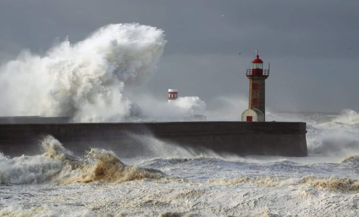
In Northern Ireland, wind gusts of up to 75mph are anticipated, especially along coastal areas. According to the forecast, these winds are likely to produce large waves capable of overtopping sea defences, potentially impacting promenades and coastal roads. The area also faces secondary yellow warnings for rain, valid from midday Monday until 18:00, with totals reaching up to 40mm over higher ground.
In south-west England, rainfall amounts between 60mm and 80mm are expected, particularly across south Dartmoor. According to the Met Office, this region has already seen high levels of rainfall this month, leaving the ground saturated and increasing the likelihood of surface flooding. A separate yellow warning covers neighbouring Wales and extends into Exmoor and Bannau Brycheiniog, where rainfall could also approach 80mm.
Additional yellow warnings apply to south-east England, beginning at midnight on Tuesday. Rainfall is forecast at 15mm to 25mm widely, with double that amount over elevated areas like the Chilterns.
Infrastructure Concerns Follow Recent Storm Impacts
Storm Chandra’s impact is intensified by its timing, arriving just days after Goretti and Ingrid. According to recent updates from BBC Weather, this has left minimal time for water levels to recede or river systems to stabilise, increasing the chance of flooding in already vulnerable zones.
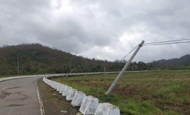
The cumulative damage from earlier storms has raised concerns over infrastructure resilience. High winds from Goretti and Ingrid have already affected south-west England in particular, leaving trees, buildings, and power lines in weakened states. As a result, authorities are warning of a higher risk of falling trees, power cuts and structural hazards during Chandra’s passage.
The government has responded with assurances regarding storm preparedness. As reported earlier by the BBC, ministers have pledged support for flood response systems and urged residents in affected areas to stay alert to local warnings and guidance.
The storm’s name, Chandra, was selected jointly by the UK Met Office, Met Éireann (Ireland) and the KNMI (Netherlands) as part of an annual naming system for weather events deemed to have medium to high impacts. The 2025–26 season began with Amy in October, followed by Bram, with Dave and Eddie next in line.
Storm Chandra adds to an already wet and turbulent start to the year. As January draws to a close, data shows rainfall totals in some regions have more than doubled their average monthly figures. With saturated ground, exposed coasts, and a succession of storms, the UK faces another testing period for its infrastructure and emergency services.