
A renewed spell of winter weather is drawing attention across the UK, with forecasts pointing to an extended period of snowfall in several regions. Weather models suggest disruption risks as January closes, followed by an uncertain transition into early February.
Snow Forecasts Raise Disruption Concerns Across The UK
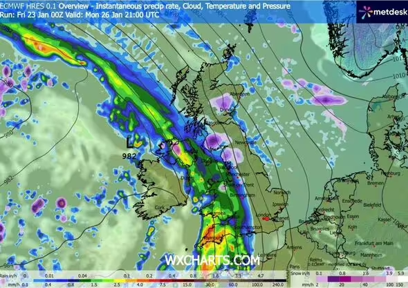
Forecast data circulating this week indicate the possibility of sustained snowfall affecting large parts of the country. According to Birmingham Live, weather modelling highlights a prolonged window in which snow showers could persist, particularly across northern England, the Midlands and Scotland. These projections rely on widely used European forecasting models that track cold air movements from the east and north-east, a pattern that has previously delivered notable winter episodes.
Meteorologists underline that such scenarios depend on small shifts in atmospheric pressure systems. A slight change in wind direction could alter where the heaviest snow settles, leaving some regions with persistent flurries while others see cold rain. Scotland appears most exposed, with higher ground facing the greatest likelihood of prolonged snowfall and local travel disruption.
While snow accumulation figures vary between models, the broader signal points to a wintry interlude that may last well beyond a single day. Transport operators and local authorities are monitoring the situation closely, particularly in areas where overnight temperatures are forecast to remain below freezing for extended periods.
Temperature Trends And Regional Weather Differences
Cold air is expected to dominate much of the short-term outlook, keeping daytime temperatures below the seasonal norm in several areas. Eastern and central regions are more exposed to this chill, while western areas may experience slightly less severe conditions due to Atlantic influences. This contrast could result in sharp regional differences, even over relatively short distances.
Looking towards the end of January and into February, Netweather TV said:
“It looks probable that we will shift into a mild and changeable south-westerly type as we head into February, but there is considerable uncertainty over how rapid this transition will be.
This means that the early part of this week in particular is still likely to have mostly below-average temperatures, with potential for wintry spells if the very cold air to the east pushes as far west as the British Isles. Later in the week there is a greater likelihood of wetter conditions with temperatures rising close to or rather above the seasonal average.
The odds thus favour below-average temperatures again overall during this week.
Precipitation is likely to be above normal in the south and east of Britain but below average in the north-west, while sunshine is likely to mirror the precipitation, below average in the south and east but well above average in the north-west.”
These assessments suggest a stop-start pattern, with cold snaps followed by brief milder phases, creating challenging conditions for forecasting at a local level.
What The Outlook Means For Late January And Early February
The evolving forecast points to a period of instability rather than a single dominant weather type. Snow risks remain present in the near term, particularly where cold air holds firm. As Atlantic systems attempt to push in from the west, the boundary between cold and milder air could lead to mixed precipitation events, including sleet and freezing rain in some areas.
Forecasters stress that confidence decreases further into early February, with outcomes ranging from a return to milder, wetter conditions to renewed cold incursions from the east. This uncertainty means short-range updates will be critical for households, commuters and businesses planning around potential weather disruption.
For now, the message from forecasters is to expect variability, with winter conditions still very much in play before any sustained shift towards milder weather becomes established.


