The month of July has started on a relatively cooler weather, with temperatures averaging about 2 °C below normal for the first half of the month. On Wednesday, Wisley in Surrey recorded a temperature of 25 °C, marking a low figure this month – which is not much for mid-summer.
Upcoming Heatwave and Health Alerts
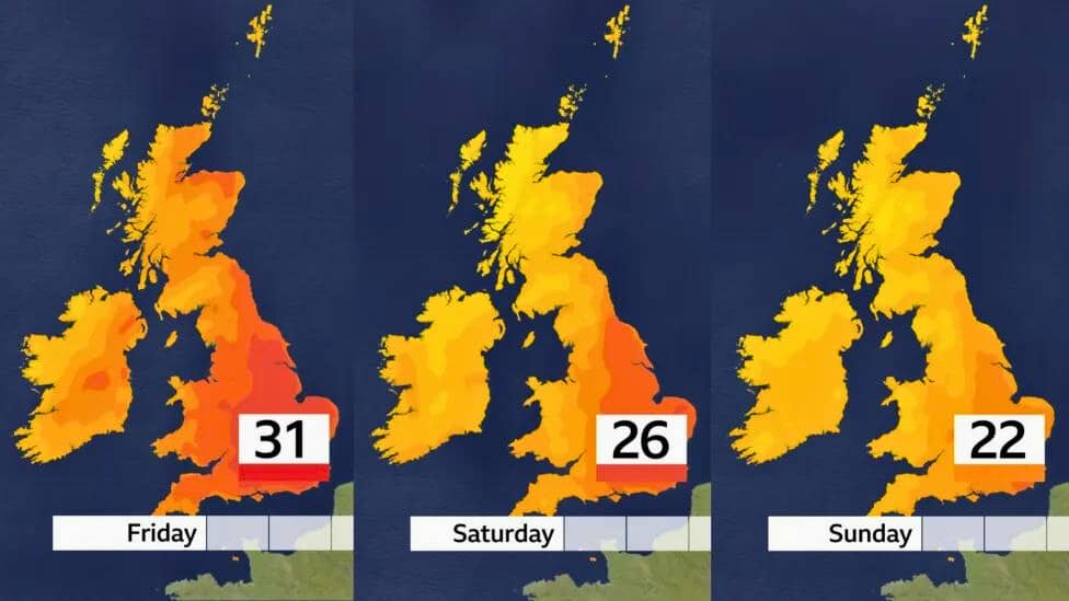
Temperature wise, it could get up to 27 or 28 degrees Celsius on Thursday, especially over parts of East Anglia and the Midlands in England. For this reason, heat health alerts have been released at 5 pm BST today for these regions.
However, it will not be hot all over the UK. There will be warm conditions in Wales and northern and western parts of England, while Northern Ireland and Scotland would be cloudier, with temperatures around average or slightly lower than that.
Potential for the Year’s Hottest Day
The momentary spike in temperatures will peak on Friday, when some areas in southern England might reach as high as 30 °C or even 31 °C, making that day possibly one of the hottest so far this year.
Currently, The highest temperature recorded was in Wisley also at Wisley with June 26th registering a temperature reading of a total of thirty point five degrees Celsius.
It may only take tenths of degrees to determine if this brief spell is hotter than that topmost temperature seen since January.
Is This a Heatwave?
A heatwave is usually considered to be when the Midlands, much of the south of England and East Anglia have at least three consecutive days when the temperature rises above 27 °C. In London and some home counties, this threshold rises to 28 °C. It appears that on these regions, most areas will just miss out on having their short spell qualify as a heat wave.
30 °C in Summer – A Common Occurrence?
Surpassing or equalling 30 °C during summers has been quite normal, with such temperatures recorded every summer since 1993. However, there are more days above 30 °C now than there were fifty years ago according to recent findings, which attribute this change mostly to climate change.
Met Office 5-DAY Weather Forecast
This Evening and Tonight:
- Tonight, there will be less rain in Scotland and Northern Ireland.
- In other areas, it will be dry with sun up to sunset.
- The upcoming night is going to be warm and quite humid.
- Most places will be dry with clear spells but some low cloud and drizzle over the northern part of the country.
Staying fine and warm with plenty of sunshine this evening across most of England and Wales 🌤️
Cloudier elsewhere with some showery rain in places 🌧️ pic.twitter.com/MiQ5Z8HGDN
— Met Office (@metoffice) July 18, 2024
Friday:
- Overcast skies are expected over the northwest, however sunny breaks will become more frequent as temperatures settle at around average levels.
- Meanwhile, there would be long periods of sunshine elsewhere, which would cause high temperatures or rather hot conditions in the open areas. It will remain mild during the night.
Outlook for Saturday to Monday:
- There is an increasing threat of rain or heavy showers on Saturday; it will stay very warm though.
- Sunday should see drier weather with brighter skies and cooler air mass in place.
- Monday will bring gusty winds accompanied by rain or showers that make one feel colder than before.


