The weather in the UK is unpredictable, especially towards the end of June. Later in the year the weather will be hot, over 30 C. But it will be hot for a short while only because there are looming clouds that signify that it is going to rain.
Rise in Temperature Recorded for All the Regions in the United Kingdom
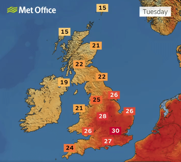
Now that June is almost, temperatures will be soaring high in the UK. Temperatures will be relatively high, with figures in excess of 30 in a number of areas, offering a real summer feel for a day or two. The heatwave is not expected to last long, however.
Some areas of the UK could see a heatwave this week. This is an extended period of hot weather compared to those expected at the time of year, but there are specific thresholds in which heatwaves occur.
Find out more in the video below or here: https://t.co/QUODT9zNwL pic.twitter.com/zWqigJPcpV
— Met Office (@metoffice) June 25, 2024
The threshold must be three consecutive hot days to be considered a heatwave. The central and eastern regions of England are expected to reach this threshold. So it will be hot, but not very hot all the time.
Weather Maps Reveals the Change to Come
It should also be noted that the maps show a noticeable change that is getting closer all the time. An impressive 800 km long barrier of rain clouds is heading towards Great Britain. It will transform hot, dry weather into wet weather.
This major change is due to take place on Tuesday, July 2, after the end of the summer holidays. As a result, the new wet front responsible for these conditions will change the weather considerably and bring heavy precipitation.
Regions Most Affected
- Eastern UK
It is the eastern part of Great Britain which is likely to suffer most from the rain. Many cities will be affected, including London, Southampton, Newcastle, Edinburgh, Cverness and Aberdeen. Residents of these regions and areas should expect heavy rainfall and difficulties with their activities.
- Western UK
On the other hand, the western regions, such as Wales and Cornwall, will be relatively warmer and wetter, with showers from time to time.
Temperature Variations
- Northern Scotland
The weather will be rather stormy, with temperatures plummeting and rising at times. Temperatures will be more moderate, in the region of 12°C, which is very different from the heat felt on previous days.
- Southern and Southeastern UK
In the south and south-east of the UK, the temperature will be slightly higher, between 12 and 20°C. These are reasonable temperatures, and the range is fairly typical of the British climate.
Met Office Long-Range Forecast
All these forecasts are in line with the Met Office’s long-term forecasts. They point to a move towards what they call “changeable weather” and “frequent precipitation”, mainly in north-western regions.
The Met Office is forecasting “cooler conditions than at the start of the week, with a westerly wind from the Atlantic”. A common pattern of warmer and wetter weather in the south will also move towards the continent.
Analysis of the forecasts shows that the north-western regions of the country will experience the heaviest rainfall, while the south and east of the country will remain largely arid.
A gradual increase in calm weather is expected, particularly in most parts of the UK, with temperatures remaining moderate to slightly above average.


