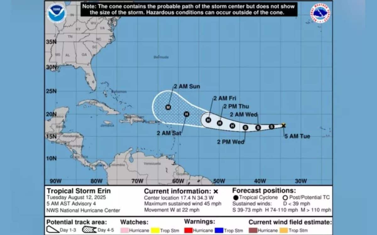
Tropical Storm Erin formed in the eastern Atlantic Ocean on Monday, becoming the fifth named system of the 2025 Atlantic hurricane season. Located near 17.4°N and 28.0°W, Tropical Storm Erin is tracking westward at 20–25 mph with maximum sustained winds of 45 mph and a minimum central pressure of 1004 mb.
According to the National Hurricane Center, tropical-storm-force winds extend outward up to 35 miles (55 km) from the center. Newsweek reported that the system is expected to intensify into a hurricane by Thursday and could reach Category 3 status over the weekend while remaining northeast of Puerto Rico.
Current Position and Environmental Conditions
As of Tuesday morning, Tropical Storm Erin was about 1,890 miles east of the northern Leeward Islands and roughly 560 miles west-northwest of the Cabo Verde Islands. The storm’s path has shifted slightly south, and models show two main scenarios for its future.
Erin will be guided westward by the Bermuda high through the Atlantic this week – Said AccuWeather lead hurricane expert Alex DaSilva.
If the trough is stronger and faster, it will help steer Erin away from the East Coast and out to sea. If the trough is slower, the storm will be able to advance farther westward toward the coast of the Carolinas. People along the East Coast, especially along the Outer Banks and eastern Canada, should monitor forecast updates closely this week.

The NHC also reported a disturbance “a few hundred miles” southeast of Nova Scotia producing “disorganized shower and thunderstorm activity to the west of its center.” Erin’s development early in the week may be limited by cooler waters and Saharan dust.
One of the reasons Erin is going to take awhile to strengthen is it’s surrounded by Saharan dust – said meteorologist Denis Phillips.
It’s gonna take some time to squash all the dust.
Forecast Track, Risks, and Seasonal Context
Most models currently favor a northward turn before Erin reaches the U.S. mainland, but experts caution that
it’s a little early to be 100 percent certain – Matt Devitt, chief meteorologist at WINK News,
noted that the latest south and west shift is “not the best” but emphasized,
It’s still early. Could snap back east (windshield wiper effect). We don’t want to jump to conclusions from 12 hours of data.
Phil Klotzbach of Colorado State University said,
We are still anticipating a slightly above average probability for major hurricanes making landfall – NOAA’s Matt Rosencrans added,
We’re still tracking closely with our initial projections. The conditions we identified in May remain largely intact.
If Erin reaches Category 3 strength this weekend, it will be the first major hurricane of 2025.
This storm will likely intensify into a major hurricane this weekend over an area with exceptionally warm waters and little disruptive wind shear – DaSilva said.
Water temperatures across much of the Atlantic main development region are plenty warm to support tropical development and even rapid intensification.
Historical Perspective and Preparedness
Originating near the Cabo Verde Islands, Tropical Storm Erin belongs to a class of long-track hurricanes that occasionally cause major U.S. impacts. While rare, these storms can be severe, as seen with Hurricane Florence (2018) and Hurricane Beryl (2024). Since 1995, only 9 of 60 U.S.-impacting hurricanes have been Cabo Verde systems.
The storm has already had tragic effects: severe flooding on São Vicente in Cabo Verde killed six people, including four children, and damaged homes, businesses, and infrastructure. The NHC advises
To ensure your preparedness plans are in place.
Dangerous rip currents and rough surf are likely along the U.S. East Coast this weekend, even without direct landfall.
Families heading to Atlantic beaches before heading back to school should be cautious and stay in areas with lifeguards on duty – DaSilva warned.
The risk of rough surf and rip currents will expand along much of the East Coast over the weekend into next week.