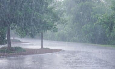
Unusually high moisture levels collided with a stalled storm system over central Texas, unleashing over 12 inches of rainfall in hours. The resulting flash floods killed dozens and left authorities grappling with swift water rescues.
The devastating flash floods that struck Texas on Friday were the result of a rare meteorological convergence. According to AccuWeather, the Texas Hill Country experienced more than 30 centimetres of rain over several hours, overwhelming natural drainage systems and causing water levels to rise rapidly.
The affected area is known for its susceptibility to flash flooding due to its steep terrain and narrow river basins. But this event was particularly lethal, occurring during the early morning when most residents were unprepared. Experts have noted the influence of a warming atmosphere in amplifying such extreme weather events.
Extreme Moisture Levels Collided With Stalled System
Meteorologists attributed the flooding to an extraordinary volume of atmospheric moisture combined with a slow-moving storm system.
According to Climate Central meteorologist Shel Winkley, the absence of the jet stream over Texas meant there was no mechanism to disperse the system.
“It’s essentially a weather system without a road to get away from the Lone Star State,” he stated.
The storm was partly fuelled by the remnants of Tropical Storm Barry, which had moved across Mexico before drifting into Texas.
Additional moisture came from the Gulf of Mexico and even the Pacific Ocean, providing further energy for the storm. Robert Henson, writing for Yale Climate Connections, described the rainfall event as a “once-in-a-generation” phenomenon due to the sheer volume of precipitation in such a short timeframe.
Former NOAA chief scientist Ryan Maue calculated that approximately 120 billion gallons of water fell on Kerr County, one of the most severely impacted regions. This intensity of rainfall overwhelmed infrastructure and caught many residents off guard, particularly those in vulnerable settings such as children’s camps.
Changing Climate Intensifies Rain Events
While scientists caution against attributing single events directly to climate change, they agree that a warming climate increases the likelihood and severity of such storms.
“With climate change we have a warming atmosphere. A warmer atmosphere holds a lot more moisture,” said Brett Anderson of AccuWeather.
This additional moisture contributes to localised, intense rainfall events rather than evenly distributed rain over time.
“Our rain events are not as uniform as what they used to be,” Winkley added, highlighting a broader shift in weather patterns. These changes mean that areas like central Texas—already flood-prone—may face even more hazardous conditions in the future.
The floods follow similar events in San Antonio and West Virginia in recent weeks, where abrupt rainfall led to fatalities and large-scale rescues.