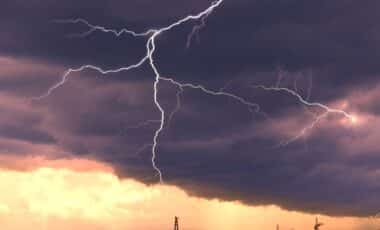
Torrential rain, destructive winds and a potentially historic storm surge threaten Jamaica and parts of the Caribbean as hurricane Melissa reaches Category 4 strength. The storm’s slow movement and uncertain track raise alarms for life-threatening flooding and landfall conditions that could severely impact infrastructure, local populations, and possibly the southeastern U.S. coastline in the coming days.
As of Sunday morning, the National Hurricane Center (NHC) confirmed that Melissa had strengthened from a tropical storm to a major hurricane in less than 48 hours. Now situated about 120 miles south of Kingston, Jamaica, it’s tracking west at only 5 mph — a near-stationary crawl that amplifies the scale of its impact.
Jamaica Braces for Historic Rainfall and Wind Impact
Melissa’s current trajectory puts Jamaica directly in the path of its most destructive core, with landfall expected between late Monday night and early Tuesday. According to the NHC, sustained winds have reached 140 mph, and storm surge levels could rise between 9 and 13 feet along the island’s southern coast. Kingston, including Norman Manley International Airport, could see direct effects from the surge and extreme rain.
Rainfall accumulations of 15 to 30 inches, with isolated totals reaching up to 40 inches, are forecast across southern Jamaica and southwestern Haiti through Wednesday. The storm has already caused flash floods and landslides in Haiti and the Dominican Republic, where several deaths have been reported, according to local civil protection authorities.
“This is a life-threatening situation,” the NHC said in a bulletin issued Sunday morning. Prime Minister Andrew Holness urged citizens to finalize storm preparations, saying: “Now is the time to secure your home… if you live in a flood-prone area, have an evacuation plan ready.”
Hospitals across the country have activated emergency protocols, halting non-urgent procedures. Public works teams in Kingston spent the weekend clearing key drainage channels such as Sandy Gully, known to overflow in heavy rain.
Slow Forward Motion Intensifies Long-Term Risk
What makes Melissa particularly dangerous is its lack of forward momentum. The storm has hovered over the Caribbean Sea for days due to an absence of dominant steering currents, much like hurricanes Harvey (2017) and Dorian (2019), which caused catastrophic flooding due to their slow pace.
According to the NHC, this sluggish movement may persist through Tuesday before Melissa begins a northeastward turn — a shift that remains uncertain and heavily dependent on emerging weather patterns over the eastern United States. If Melissa turns earlier, it could spare the U.S. coast. A delayed turn may increase the risk of impacts on Florida or the southeastern seaboard.
Still, the storm’s reach is already being felt. Swells generated by Melissa are expected to cause dangerous surf and rip currents along parts of the U.S. East Coast this week. Coastal residents are advised to remain alert, particularly in Florida, as meteorologists monitor changes in Melissa’s trajectory and intensity. With peak hurricane season continuing, forecasters warn this type of rapid intensification and erratic movement may become more common.