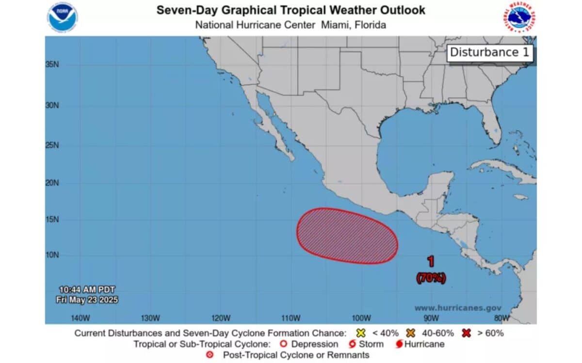
The National Hurricane Center (NHC) is closely observing a developing weather disturbance located several hundred miles south of the Mexican coastline.
Forecasters suggest this system has the potential to evolve into the first tropical storm of the 2025 Eastern Pacific hurricane season, forming notably earlier than is typical for the region.
According to Newsweek, which cited official forecasts and expert commentary, conditions appear increasingly favorable for gradual development over the coming days.
While the exact trajectory and intensity remain uncertain at this stage, the situation is drawing attention from meteorologists monitoring early-season storm activity in the Pacific basin.
Monitoring a Disturbance With High Potential
As of Friday, the NHC reported:
“An area of low pressure is expected to form early next week several hundred miles south of the southern coast of Mexico. Conditions appear favorable for development of this system, and a tropical depression is likely to form around the middle of next week while moving westward to west-northwestward at 10 to 15 mph.“
Currently, the chance of a tropical depression forming in the next 48 hours is near zero. However, there is a high chance—estimated at 70 percent—that a system will form within the next seven days, as per the NHC’s seven-day outlook.
The Eastern Pacific hurricane season officially began on May 15, whereas the Atlantic and Central Pacific seasons start on June 1. Historically, the first tropical system in the Eastern Pacific forms around June 10, meaning the current disturbance is forming well ahead of schedule.
Broader Seasonal Outlook
AccuWeather forecasts 14 to 18 tropical storms and 7 to 10 hurricanes for the Eastern Pacific in 2025. This compares with a seasonal average of 15 storms and 4 hurricanes, indicating a potentially more active season than usual.
In the Atlantic basin, the National Oceanic and Atmospheric Administration (NOAA) expects 13 to 19 named storms, 6 to 10 hurricanes, and 3 to 5 major hurricanes. The 2025 season is expected to be above average, continuing the pattern observed in recent years.
Early Signs and Expert Commentary
A recent AccuWeather report noted that although there is no active tropical system currently in the Eastern Pacific, “showers and thunderstorms are beginning to show signs of organization.“
Alex DaSilva, lead hurricane expert at AccuWeather, stated:
“Signs continue to point toward some slow tropical development off the Pacific coast of Central America and south of the southwestern coast of Mexico prior to the end of the month. At this time, we believe a tropical feature may organize sometime from May 26 to May 30, especially the latter part of that period.“
Laura Grimm, Acting Administrator of NOAA, also commented on the upcoming Atlantic season:
“As we witnessed last year with significant inland flooding from hurricanes Helene and Debby, the impacts of hurricanes can reach far beyond coastal communities. NOAA is critical for the delivery of early and accurate forecasts and warnings, and provides the scientific expertise needed to save lives and property.“