The UK is bracing for exceptional weather conditions in the lead-up to Christmas, with heavy snowfall, freezing temperatures, flood warnings, and major transport disruptions. Forecasts indicate that these severe conditions will affect much of the country between 22nd and 24th December, particularly the north, west, and coastal areas.
Widespread Snow and Freezing Temperatures Predicted
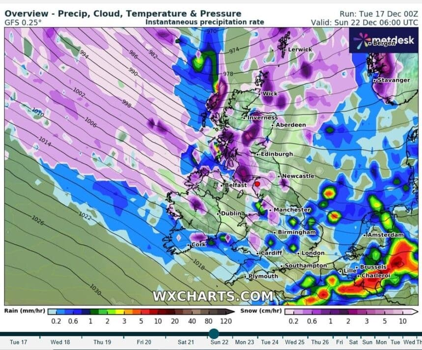
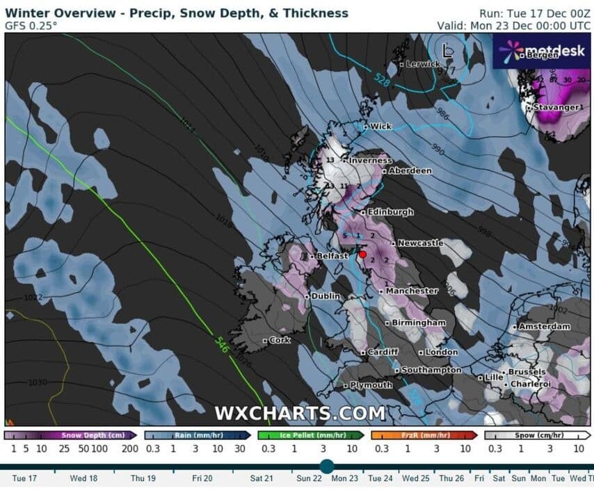
Forecasts indicate that heavy snow will impact numerous regions, particularly Scotland, northern England, and Northern Ireland. According to WX Charts and the Met Office, intense snowfall is expected to begin as early as 22nd December, continuing through to 24th December. Significant accumulations are predicted in areas such as the Scottish Highlands and northeastern England.
Freezing Temperatures and Ice Hazards
Temperatures are set to be particularly cold, with -2°C potentially being reached in the Scottish Highlands, and hovering around 0°C in the West Midlands. Snowfall is expected to melt and then refreeze, creating icy roads, especially in urban centres like Edinburgh and Glasgow, posing significant travel risks. In southeast England, conditions are expected to be milder, but the ice hazard remains a danger, particularly in rural areas.
30 Hours of Continuous Snow and Severe Disruptions Likely
The forecast also predicts a 30-hour period of continuous snow, which is expected to start on 23rd December, primarily affecting the north. The snowstorm could last through to 24th December, impacting areas such as Manchester, Liverpool, and further north. As reported by Sky News, these conditions could result in significant snowfall, severely disrupting rail and air transport.
- Duration of the snowstorm: 30 hours of continuous snow.
- Most affected areas: Wales, northern England, Northern Ireland.
- Impact on transport: Likely road closures and train cancellations, particularly on services operated by Great Western Railway.
Rail networks are expected to experience widespread disruption due to snow and icy conditions. Train cancellations are predicted, particularly on services running between London and the north. Railway authorities have urged travellers to check train services before travelling.
Flood Alerts and Increased Risk of Inundations
Another major concern is flooding. As the snow melts and heavy rain falls, the UK is under over 200 flood alerts, with severe flood warnings issued for areas such as Billing Aquadrome near the River Nene and other densely populated areas, including parts of Wales.
Rivers are at risk of exceeding their critical levels, posing a danger to residents. The Met Office has warned that flooding may occur rapidly, and local populations should stay alert and follow official instructions to avoid danger.
Additional Disruption Risks
Authorities have also warned that strong winds and torrential rain will accompany the snow, further exacerbating the risk of flooding. Power outages are likely as the storm progresses, and previous storms have already caused widespread disruptions to electricity supply.
- Severe flood alerts: Over 200 active alerts across the UK.
- High-risk regions: Wales, northern England, River Nene area.
- Potential impact: Flash flooding, power outages, and emergency service disruption.
Official Recommendations
Authorities are urging the public to stay updated on weather warnings, prepare emergency kits in case of power outages, and check transport updates regularly. Travellers are advised to avoid long-distance travel during peak hours due to the risk of slippery roads and ice hazards.
Emergency services and weather agencies are preparing contingency plans to mitigate the impact of these extreme weather conditions on daily life and infrastructure. Drivers are advised to maintain safe distances on icy roads and check road conditions before setting out.


