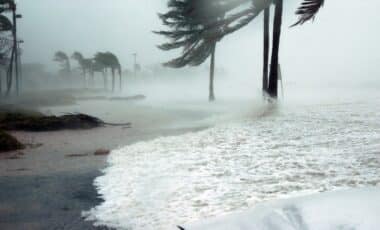
Coastal New South Wales is preparing for another round of wild winter weather, with the Bureau of Meteorology warning of heavy rainfall, strong winds and hazardous surf conditions from Friday night. The developing low-pressure system could bring severe impacts from the Hunter region through Sydney to the Illawarra.
Residents awoke on Wednesday to persistent rain and cold conditions across central and eastern NSW. According to the Bureau of Meteorology (BoM), this unsettled weather will intensify over the coming days, potentially leading to flash flooding and coastal hazards.
Low-Pressure System Expected to Intensify
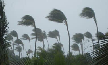
A low-pressure system forming off the state’s north coast is forecast to rapidly deepen, bringing widespread rainfall and strong winds to large parts of NSW. According to BoM meteorologist Jiwon Park, the system is expected to peak on Saturday, with damaging winds of up to 60 km/h and gale-force gusts of 90 km/h along coastal fringes.
“This is a dynamic weather event,” senior meteorologist Christie Johnson stated. “Forecasts are likely to change before the weekend as we get more information about the position of that low.” The bureau also warned that daily rainfall totals could reach between 50 and 100 millimetres in parts of the Hunter, the Central Coast and the Sydney metropolitan area, raising the risk of flash flooding and river rises.
Snow is also possible above 1,000 metres in the central and northern ranges, creating additional challenges for transport routes outside the usual alpine areas. The NSW State Emergency Service (SES) has urged residents to prepare emergency plans and monitor the Hazards Near Me app for updates.
Emergency Services Warn of Heightened Risks
Authorities are emphasising the importance of early preparation. Nicole Hogan, SES assistant commissioner, warned that many catchments across NSW remain saturated from recent weather events and could “respond quickly” to renewed rainfall, increasing the risk of dangerous flooding.
“We ask everyone to stay informed by downloading the Hazards Near Me app and setting up a watch zone for their area, so you are alerted with the latest warnings and advice.,” Hogan said.
The SES has highlighted the potential for flash flooding, hazardous coastal conditions and significant wave activity along the shoreline. According to the bureau, once the first low-pressure system moves inland, a secondary system could affect the north coast of NSW on Sunday, bringing further strong winds and intense surf.
Earlier this month, a powerful storm left tens of thousands of residents without power and prompted more than 1,300 emergency calls in 24 hours. With similar conditions now predicted, authorities are urging vigilance as NSW braces for another challenging weekend.