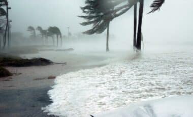
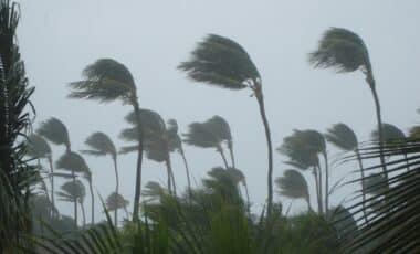
A powerful cold front sweeping through New South Wales has caused major disruptions in Sydney and its surrounding regions. With strong westerly winds hitting the coast, authorities have issued several warnings, and communities are facing significant challenges due to fallen trees, powerlines, and widespread flight delays. This stormy weather has forced Sydney Airport to reduce its operations, leaving travelers stranded and local authorities scrambling to manage the damage.
The cold front, which brought gale-force winds and rain, continues to affect the region, with the Bureau of Meteorology warning of ongoing risks of damaging gusts. As Sydney grapples with the storm, experts and emergency services are working to minimize the impact of these extreme conditions.
Sydney Airport Faces Major Disruptions
The winds have wreaked havoc at Sydney Airport, with gusts of up to 93 km/h recorded just after 9 am. In response to the extreme weather conditions, airport operations were reduced to a single runway, causing significant delays and cancellations for flights in and out of the city. The country’s air navigation service provider, Airservices Australia, confirmed that the limited operations were necessary to ensure passenger safety in line with international aviation regulations.
Travelers were urged to contact their airlines for the latest updates, as the stormy conditions were expected to cause further disruptions throughout the day. With the winds continuing to pick up, authorities warned of additional delays and potential cancellations.
⚠️Issued 10:32am
— Bureau of Meteorology, New South Wales (@BOM_NSW) June 25, 2025
Damaging winds about the Great Dividing Range as well as southern and central parts of the coast.
🌬️117km/h wind gust recorded at #Bellambi at 9:03am
🌬️98km/h wind gust recorded at #Wollongong at 9:10am
See: https://t.co/IqMkyCBVbf#Newcastle #Goulburn #Nowra pic.twitter.com/2523CrQvml
Strong Winds Lead to Widespread Damage
As the storm moved across the state, wind gusts intensified in several areas. The South Coast was hit hardest, with Bellambi recording winds at 117 km/h. Other locations, such as Thredbo, Wollongong, and Moss Vale, saw gusts reaching between 89 km/h and 100 km/h. The powerful winds have caused extensive damage to infrastructure, with trees and powerlines falling in multiple locations, resulting in traffic disruptions and power outages.
One of the most significant incidents occurred in Wollongong, where a 100 km/h gust caused roof damage at a property on Keira Street. Emergency services, including police and the State Emergency Service (SES), were quickly called to respond to the damage and prevent further harm to residents.
Emergency Services on High Alert
In light of the escalating conditions, emergency services have been on high alert throughout the region. The SES issued warnings urging people to secure loose items, avoid parking under trees, and stay clear of fallen powerlines. Police and rescue teams were deployed to areas where trees had fallen on roads, blocking traffic and causing chaos.
Authorities are closely monitoring the situation and continue to provide updates as the cold front moves northwards. The SES has emphasized the importance of driving carefully and remaining alert to the hazards posed by the storm’s aftermath.

Bureau of Meteorology Issues Ongoing Warnings
The Bureau of Meteorology (BOM) has warned that the severe winds are expected to continue across parts of New South Wales. Areas such as Newcastle, the Hunter region, and the Northern Tablelands could experience further disruptions, with winds potentially exceeding 100 km/h. The BOM has issued a special weather statement for these areas, highlighting the risks of falling trees and flying debris.
Residents across the state are advised to follow local guidance and stay indoors during the peak of the storm to avoid unnecessary risks. The authorities continue to issue regular updates on the weather conditions and urge the public to stay informed as the cold front moves through the region.