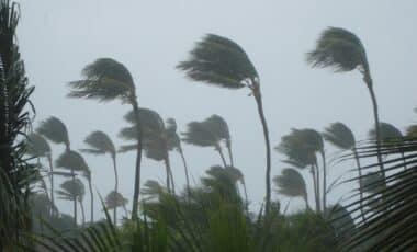
Sydney has officially experienced its coldest day of 2025 so far, with temperatures plummeting early on Wednesday, June 4. The chilly conditions are attributed to a combination of a polar airmass, gusty winds, and persistent showers, which have made the day feel colder than usual. As the city grapples with this cold front, residents are left to cope with unseasonably low temperatures, particularly in the early morning hours.
The coldest temperatures were recorded at 9 am, with Sydney’s air temperature reaching 10.4°C and an apparent temperature, or “feels like” temperature, dipping to just 5.3°C. This is a stark contrast to Sydney’s usual winter conditions, where residents are accustomed to milder, more temperate weather. This significant cold front marks a sharp departure from the norm for the city, which often sees daytime highs in the mid-teens during the month of June.
Beyond the City: Suburban and Regional Cold Snap
While Sydney’s central business district is feeling the chill, the suburbs and regional areas are experiencing even colder temperatures. Parts of the Blue Mountains, just outside the city, recorded a temperature of 2.5°C at 9:30 am, with an apparent temperature of –2.9°C due to gusty winds coming from the south and southwest. These areas are familiar with colder conditions, but for Sydney itself, these low temperatures are rare in the daytime.
In contrast, the Northern Beaches suburb of Terrey Hills, situated 199 meters above sea level, recorded 8.7°C at the same time, with an apparent temperature of 4.8°C. These readings highlight how temperatures can vary significantly across the region, especially as you move away from the coastline and into higher elevations.
The Role of the Low-Pressure System
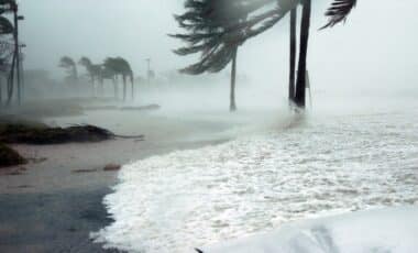
The driving force behind Sydney’s cold day is a powerful low-pressure system sitting over the Tasman Sea, positioned halfway between the New South Wales coast and New Zealand’s North Island. This system is responsible for the cold southerly winds sweeping across eastern Australia, contributing to the cold temperatures in Sydney and the surrounding regions.
In addition to the cold air, this low-pressure system is generating large swells along the New South Wales coastline, creating hazardous surf conditions. A hazardous surf warning is currently in place for several areas, including the Byron Coast, Coffs Coast, Macquarie Coast, Hunter Coast, Sydney Coast, and the Illawarra Coast. Gale-force winds and strong winds are expected to persist, exacerbating the already chilly conditions.
A touch of winter today in Sydney. The mercury will plunge to 15C. Are we all tucked up, toasty warm? pic.twitter.com/hrpmVPcNOt
— Jo Gubret (@Guy869Jo) June 4, 2025
Snowfall and Alpine Conditions
The cold front is also affecting the alpine regions of New South Wales and Victoria, where snow has been falling. The snow is accumulating in areas like the Blue Mountains and further inland, with some parts seeing up to 2 cm of snow. The chilly conditions in the mountains have extended to mid-morning on June 4, and snow showers are expected to continue for the rest of the day.
As the weekend approaches, significant snowfall is predicted for the region, coinciding with the official start of the 2025 Australian snow season. Skiers and snowboarders are already preparing for the arrival of substantial snowfalls, which could mark the beginning of a promising winter for the Australian Alps.
Coastal Impacts and Future Forecasts
The cold front’s impact on the NSW coast is not limited to just temperatures and snow. Along with the hazardous surf warning, residents and visitors along the coast are being cautioned about the dangerous conditions. The powerful low-pressure system has also made its way inland, bringing moisture to the alpine region, which will continue to see light snow showers throughout the day.
As the system moves eastward, it is expected to ease later in the week, with a brief dry spell forecast for the mountains before the next round of snow begins. This ongoing weather system underscores the variability and intensity of winter weather in eastern Australia, with significant shifts in temperature and weather patterns occurring rapidly.