A powerful cold front has surged across southeastern Australia, bringing a rare burst of winter weather to regions unaccustomed to such conditions. This unusual weather system, which has brought polar air well into lower elevations, is affecting New South Wales (NSW) and Victoria, resulting in significant snowfalls. For many in these areas, it marks the arrival of snow at elevations lower than the typical alpine zones, creating unexpected winter scenes.
As the school holidays in NSW and Victoria begin, this sudden change in weather has brought both excitement and logistical challenges. For snow enthusiasts, the fresh accumulation has transformed local ski resorts, providing a timely boost to the winter season. However, the cold front’s impact extends beyond the mountains, with major cities experiencing sharp drops in temperatures.
Winter hits lower-than-usual regions in southeastern Australia
This week’s cold front has pushed polar air into southeastern Australia, causing precipitation to fall at elevations much lower than the usual alpine regions. Flurries are forecast to reach areas as low as 800 to 900 meters in places like Orange in the NSW Central Tablelands. These areas, typically too low to experience wintry weather, are now preparing for a rare winter event. The official Bureau of Meteorology (BoM) forecasts confirm that these regions will see snowflakes, indicating that this is not merely a brief cold spell but a significant change in the weather pattern.
The arrival of snow at such low elevations marks a sharp departure from the typical Australian winter, where the white stuff is generally confined to much higher altitudes. The town of Orange, sitting at 900 meters, is among those poised to experience this unusual occurrence, making it a significant event for the area.

Major Ski Resorts Benefit From Fresh Snow
In higher elevations, the cold front has delivered much-needed accumulations to popular ski resorts in Victoria and NSW. Resorts such as Thredbo, Perisher, Hotham, Falls Creek, and Mt Buller have reported up to 20 cm of fresh snowfall, significantly improving conditions for skiers and snowboarders. This new layer comes at the perfect time for the NSW and Victorian school holidays, when families typically head to the slopes.
The fresh accumulation provides a vital boost for these resorts, which rely on consistent weather patterns to support their winter tourism seasons. With more precipitation expected in the coming days, both resort operators and visitors are hopeful for an extended winter experience. The new layers ensure excellent conditions for skiing and snowboarding throughout the remainder of the season.
Absolute scenes this morning at Mt #Hotham. 29cm in the #snow storm total and it’s dumping down. It’s #snowmageddon Winter 2025 is ON! ❄️❄️❄️ pic.twitter.com/WbI8OwEWf7
— Hotham (@_hotham) July 9, 2025
Uncommon Snow Conditions in Victoria
In a rare twist, certain regions in Victoria have experienced conditions typically seen in colder climates, such as Japan. At Mt Hotham, for instance, the recent accumulation has been described as light, dry, and powdery—traits uncommon in Australia, where the typical snowfall is heavier and wetter. This dry, fluffy consistency has made the current weather event an exceptional one for the region.
This type of precipitation, which is rarely found in Australia, offers a distinct experience for skiers and snowboarders. The lighter powder is ideal for certain snow sports, providing an excellent surface for both activities. Skiers at Mt Hotham have already reported favorable conditions, with the unusual texture attracting significant attention from winter sports enthusiasts.

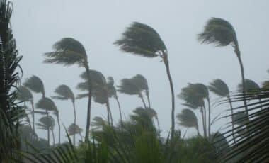
Cold Front Brings Sharp Temperature Drops
The polar air not only brought snow, but also significantly lowered temperatures across southeastern Australia. Cities like Melbourne and Canberra are experiencing unusual cold, with Melbourne’s maximum temperature forecast to be only 12°C on Thursday, and Canberra struggling to reach 8°C. In some parts of Canberra, sleety rain has been reported, as the cold front continues to move through the region.
These temperatures are well below the usual seasonal averages, with residents in affected areas preparing for more of the same over the next few days. The cold front is expected to persist, with another wave of cold air arriving on Monday, ensuring that the chilly conditions remain a fixture for the immediate future.