Millions of Australians across Queensland and northern New South Wales are preparing for Tropical Cyclone Alfred, which is expected to make landfall within the next 72 hours. The Bureau of Meteorology (BOM) has issued warnings for severe weather conditions, including damaging winds, heavy rainfall, and potential flash flooding.
When and Where Will Cyclone Alfred Make Landfall?
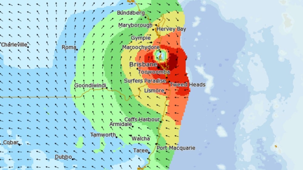
Cyclone Alfred is forecast to cross the southeast Queensland coast late Thursday night or early Friday morning as a Category 2 storm. The affected regions include areas from Sandy Cape to Grafton, covering major cities such as Brisbane, the Gold Coast, Sunshine Coast, and Byron Bay.
As of Tuesday morning, the storm was located approximately 560 kilometers east of Brisbane, with wind gusts reaching up to 130 km/h. The BOM has warned that these winds will strengthen as the cyclone approaches the coast.
Forecasters have also indicated that while the cyclone is currently tracking toward the southeast Queensland coast, its path may shift slightly in the coming days, potentially expanding the areas affected.
Expected Weather Impacts
Cyclone Alfred is expected to bring severe weather conditions to the impacted regions. Wind speeds could reach 120 km/h, with the potential for even stronger gusts in some areas. These winds may cause structural damage, knock down trees, and lead to power outages.
Heavy rainfall will accompany the cyclone, with daily totals expected to range between 200 and 400 millimeters. This level of precipitation significantly increases the risk of flash flooding, particularly in low-lying areas and near river systems that are already saturated from previous rains.
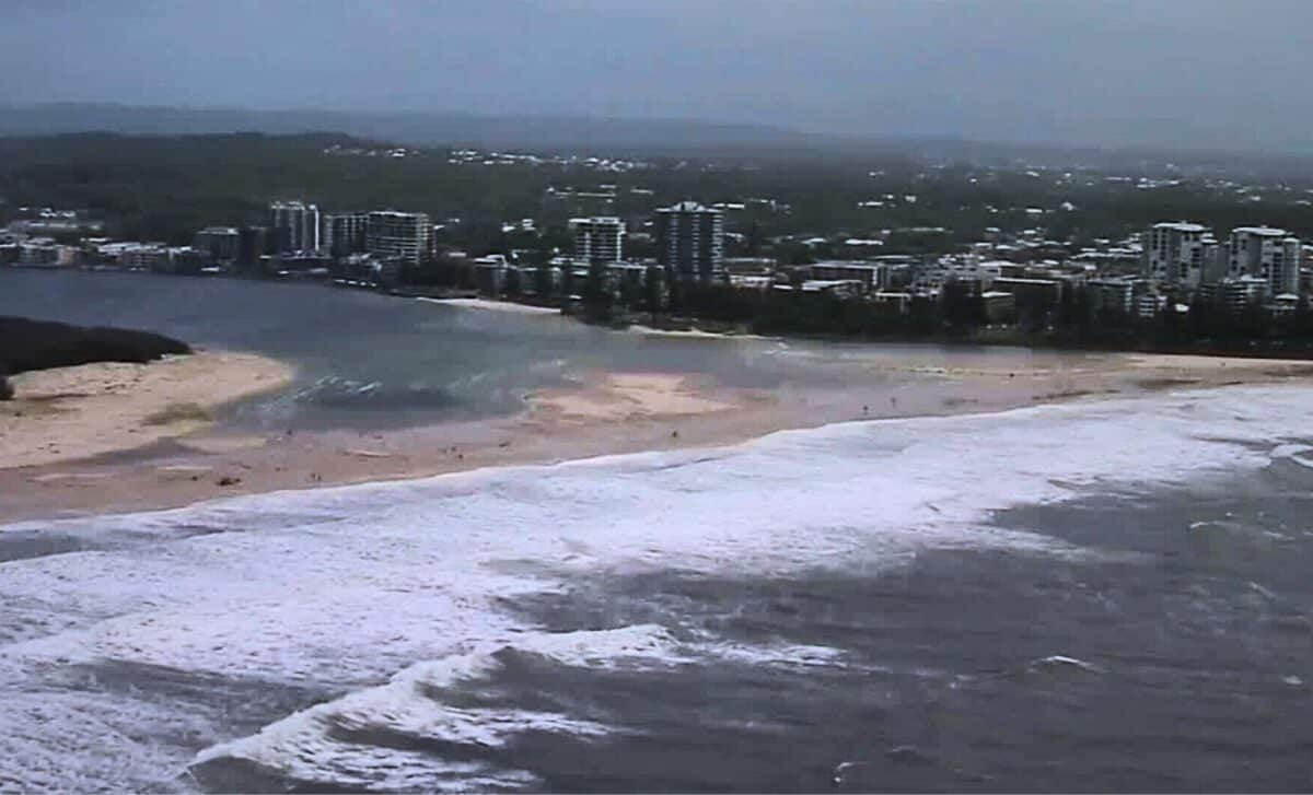
Authorities warn that some areas may experience rapid rises in floodwaters, cutting off roads and access to essential services. Coastal regions are also expected to face hazardous conditions, with waves reaching up to eight meters.
These extreme surf conditions could lead to coastal erosion, putting properties along the shoreline at risk. Beachgoers and residents in vulnerable areas are advised to stay away from the water as the cyclone approaches.
Preparation and Safety Measures
Emergency services are urging residents to take precautionary measures before the cyclone arrives. Authorities recommend securing loose outdoor objects, which could become dangerous projectiles in high winds.
Residents are also advised to check their emergency kits, ensuring they have essential supplies such as food, water, medications, and batteries in case of power outages.
Staying informed is crucial, and people in affected areas should follow official weather updates from the BOM and local emergency services.
Authorities have emphasized the importance of avoiding unnecessary travel once severe weather conditions begin, as flooding and debris could make roads impassable.
In flood-prone areas, sandbagging stations have been set up to help residents protect their homes and businesses. Those in vulnerable locations are encouraged to take advantage of these resources as early as possible.
Event Cancellations and Disruptions
With the cyclone approaching, several major events have already been postponed or canceled. Among them are the Mooloolaba Triathlon and the Hyundai Australian Boardriders grand final, both of which were set to take place this week. Organizers cited safety concerns and the likelihood of extreme weather conditions as reasons for the changes.
Public transport services and flights may also experience delays or cancellations as the cyclone moves closer. Authorities are monitoring the situation and will issue updates regarding road closures and transport disruptions as necessary. Residents and travelers are advised to check for updates before making any plans.
A Rare Cyclone Event for Southeast Queensland
Tropical cyclones of this strength rarely reach southeast Queensland, making Cyclone Alfred a significant weather event. The last time a tropical cyclone made landfall in this region was in 1974, when ex-Tropical Cyclone Zoe caused widespread damage.
Meteorologists are closely tracking the cyclone’s movement, and further updates will be provided as it nears the coast. Residents in affected areas are advised to remain vigilant, take necessary precautions, and follow official warnings and safety advice.