
A powerful cold front is expected to cross southeast Australia, bringing significant weather changes early next week. Beginning Monday, June 16, and continuing into Tuesday, June 17, the front will generate gusty winds, widespread showers, and a fresh burst of alpine snow as it pushes across South Australia, Victoria, Tasmania, and southeast New South Wales. These conditions are expected to have a considerable impact on daily life, travel, and outdoor activities in the affected regions.
This cold front is poised to affect millions of residents across several states, with a marked shift in weather patterns. The front’s arrival signals a temporary disruption, but also a crucial boost for alpine resorts, which will benefit from the fresh snow. Understanding the timing and intensity of the cold front is important for local communities and travelers, particularly those heading to the mountains or coastal areas.
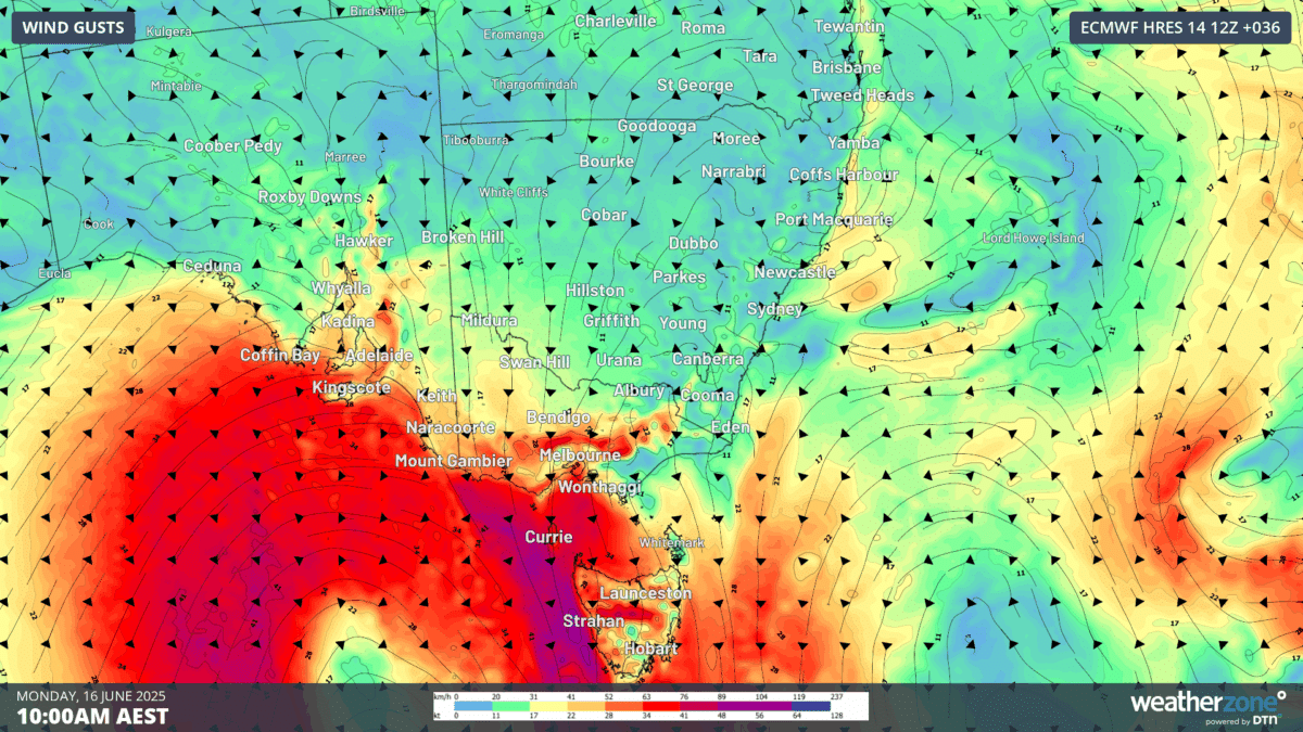
Gusty Winds Sweep Through Southeast Australia
The most immediate impact of the cold front will be the arrival of strong winds across the affected regions. On Monday, South Australia will feel the brunt of these winds, with gusts reaching speeds of 50 to 75 km/h. Adelaide and the Mount Lofty Ranges are expected to experience these powerful gusts as the front sweeps through. The winds will then move eastward, with Victoria experiencing even stronger gusts. In some areas of Victoria and Tasmania, wind speeds could peak near 90 km/h, especially in higher terrain. Melbourne, in particular, is forecast to see gusts of 60 to 75 km/h, which may cause temporary disruptions to transport and outdoor activities.
By Tuesday, the winds will persist, particularly across Victoria, Tasmania, and parts of southeast New South Wales. Alpine areas in these regions may continue to experience gusts approaching 85 km/h, creating hazardous conditions for anyone venturing into the mountains.
⛈️Widespread pop-up thunderstorms will develop this afternoon and evening across the southeastern US.
— WeatherFront (@WxFront) June 14, 2025
⬇️Here’s the latest run of the 15-minute RRFS, a model exclusively available on WeatherFront! pic.twitter.com/WXgkRjdVQ0
Widespread Showers and Isolated Thunderstorms
Along with the strong winds, widespread showers are expected to accompany the cold front as it moves across the southeast. These showers will affect much of the region, with some areas experiencing brief, heavy rainfall. The coastal stretches and range country of northern and western Tasmania are particularly likely to see rainfall totals of 20–50 mm. Thunderstorms may also develop, further intensifying the rain in some areas. The possibility of localized flooding or difficult travel conditions will be a concern for residents and travelers, particularly in areas prone to flash flooding.
The timing of these showers suggests that conditions may be unsettled for much of Monday and Tuesday, with the heaviest rain expected along the coastline. While the rain will provide some relief to drought-affected areas, the stormy weather could create challenges for outdoor activities and transportation networks.
Snowfall to Blanket the Alps
One of the key features of this cold front is the fresh snow expected in the Alps. Snow will begin to fall late on Monday night, with an additional 10 to 15 cm expected by Tuesday or early Wednesday. This fresh layer of snow is expected to benefit ski resorts by bolstering the snow base, which is vital for the upcoming ski season. However, the strong winds associated with the cold front may create challenging conditions for skiers and snowboarders, including poor visibility and white-out scenarios in alpine areas.
While the snow will bring excitement for winter sports enthusiasts, it will also make travel to higher elevations more hazardous. Those heading to the resorts should be prepared for reduced visibility and rapidly changing conditions on the slopes, particularly on Tuesday, when the wind will still be a significant factor.
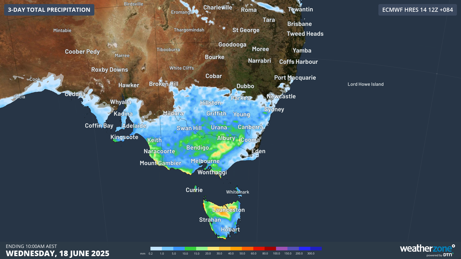
Image: Accumulated precipitation across south east Australia to 10 am AEST Wednesday 18 June (ECMWF).
Calm After the Storm
By the middle of the week, the weather will begin to settle. A ridge of high pressure will move in from the west, gradually easing the strong winds and allowing sunnier and calmer days to take hold. This change will provide a welcome break from the wild weather experienced at the start of the week.
The conditions will also be ideal for enjoying the fresh snow that has accumulated in alpine regions. From Wednesday through Saturday, southeast Australia can expect clearer skies and more stable weather, allowing residents and visitors to take advantage of the improved conditions.