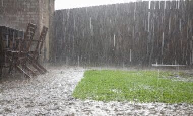
A massive cold front, stretching over 3,500 kilometers, is set to sweep across Australia this week, offering some relief to drought-stricken regions. This weather system brings much-needed rainfall, marking a significant change for areas that have been facing severe dry conditions for several years. The rain event, which is part of a larger series of systems, promises to be the most substantial rainfall of the 2025 winter season. While it won’t break the drought entirely, it is expected to provide the most significant respite for farmers in the hardest-hit regions.
Australia’s drought, particularly in the southern states, has worsened due to a combination of high-pressure weather systems and the long-term impacts of climate change. This large-scale weather event is seen as a crucial moment in the fight against ongoing drought, especially for those in agricultural areas that have seen little relief in recent years.
The Ongoing Drought in Southern Australia
Southern Australia, including areas like the Wheatbelt in Western Australia, the agricultural regions of South Australia, and parts of Victoria and Tasmania, has been dealing with a persistent drought for several years. Southeast South Australia has been particularly impacted, experiencing the driest January to May period on record. As the region enters its third year of drought, the land has become increasingly difficult to sustain crops, even when rainfall does occur. The dry conditions have led to widespread soil degradation, which limits the ability of the land to absorb moisture, making it harder for crops to grow.
The primary driver behind these conditions is the presence of high-pressure systems that block rain-bearing cold fronts. These systems prevent the passage of moisture-laden air from the tropics and stall the development of significant rainfall, resulting in a cycle of dry spells during crucial planting and growing seasons.

Climate Change’s Role in Intensifying Drought
The lack of cool-season rain, especially during the crucial months of April to October, has been increasingly linked to broader climate trends. According to the CSIRO in their 2024 State of the Climate report, the frequency of high-pressure systems over southern Australia has increased, largely due to the warming climate. This shift has led to prolonged dry spells, particularly in the south-west and south-east regions, where below-average rainfall has become more common. The CSIRO highlights that the impacts of climate change have exacerbated these conditions, contributing to a decrease in rainfall during what should be the cooler, wetter months of the year.
This trend aligns with the broader pattern of reduced rainfall across many of Australia’s key farming areas, including regions like Western Australia, South Australia, and parts of Victoria. These areas rely heavily on rain during the winter months to sustain crops and ensure food security, making the long-term trend toward drier conditions a major concern for agricultural productivity.
A Shift in Weather Patterns Brings Hope
While recent conditions have been grim, the arrival of cold fronts in recent weeks has provided some relief. The first cold front of the week began moving through Western Australia and South Australia by Monday, bringing gusty winds and cooler temperatures, along with some rain. This was seen as a promising sign that weather patterns might be shifting, providing the region with the rainfall it desperately needs. However, the next cold front, set to hit the coast on Wednesday, is expected to deliver even more substantial rain.
The cold front, aided by moisture-laden air from the tropics, will bring heavy rainfall and thunderstorms, followed by widespread, steady rain across the southern regions by Friday. Rainfall totals of 10-30mm are expected across South Australia, north-west Victoria, and western New South Wales, with the system continuing its march across the Murray-Darling Basin, Queensland, and parts of the Northern Territory by the weekend. This will provide much-needed moisture to some of the hardest-hit farming areas, although it will not fully resolve the drought.

Multi-State Severe Weather Warnings Expected
As the cold front progresses across Australia, it is likely to generate severe weather, including strong winds and storms. The Bureau of Meteorology is expected to issue multi-state severe weather warnings as the low-pressure system moves through the south-east of the country. These warnings could highlight the risk of damaging winds, along with heavy rainfall and the possibility of localized flooding in areas that receive the heaviest rainfall.
The widespread nature of the event is expected to benefit up to 80% of the nation, though some regions will experience more significant rainfall than others. Despite being a major event for drought relief, this rain will not be enough to break the drought completely, as the region will require more consistent rainfall throughout the year to recover from the effects of prolonged dry conditions.