New South Wales’ Mid North Coast is bracing for sustained heavy rainfall and increasing flood risks as a severe weather system continues to affect the region. Since late Sunday night, the area between Newcastle and Kempsey has experienced significant rain accumulation, with some locations seeing more than 100 millimeters in a short span. This intense weather event is accompanied by strong winds and hazardous surf, creating multiple safety concerns for residents and visitors alike.
The prolonged nature of the storm means that the risk of flooding remains high for several rivers and waterways, with authorities issuing flood warnings and urging the public to stay alert. The ongoing conditions highlight the vulnerability of coastal and inland communities in this part of New South Wales and the importance of preparedness and caution during such extreme weather events.
Persistent Heavy Rainfall and Severe Weather Warning
According to the Bureau of Meteorology, as much as 120 millimeters of rain fell in Port Macquarie between 9 am and 4 pm on Monday, with sustained rainfall affecting the broader Mid North Coast. Intense winds have also been recorded, including 70 km/h sustained winds at Norah Head and gusts up to 94 km/h at Nobby’s Signal Station. The bureau has updated its severe weather warnings, extending alerts to the Hunter, Northern Tablelands, and North West Slopes and Plains regions.
The BOM cautions that prolonged moderate rainfall, with isolated heavy falls, may lead to flash flooding. Particularly at risk are coastal areas between Seal Rocks and Nambucca Heads, as well as elevated inland parts of the Mid North Coast district, where persistent heavy showers and thunderstorms may result in dangerous and life-threatening flooding.
Forecast and Meteorological Insights on Ongoing Impact
Sky News meteorologist Marina Neuman described the rainfall over the past 24 hours as “just the beginning,” with more rain expected throughout the week. The weather system, characterized by a coastal trough, is forecast to linger, bringing moist air onshore and affecting areas extending as far west as Tamworth, Dubbo, and Orange.
Neuman noted that the heaviest rainfall totals are expected to remain in the northern sections of the affected region, moving slowly between areas north of Sydney up to Port Macquarie. By the end of the week, the storm system is projected to shift further north toward Lismore before moving away from the coast, while Sydney could still receive around 75 millimeters of rain.
Flood Alerts for Rivers and Communities
Flood warnings are in place for several river systems across the region. Major flooding is a concern for the Paterson and Williams Rivers, particularly around Gostwyck, Dungog, and Mill Dam Falls, where flooding could begin as early as Tuesday afternoon. Minor flood warnings have been issued for Tuggerah Lake, the Warrego River, and the Darling River, with a minor to major flood alert in effect for the Manning and Gloucester Rivers.
Residents living near these waterways have been advised to monitor local updates closely and prepare for potential evacuations or disruptions. Emergency services continue to coordinate responses to mitigate the impact of rising waters and safeguard communities.

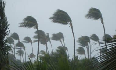
Heavy rainfall is set to continue for the Mid North Coast region of New South Wales with the potential for upwards of 200 millimetres. Image Credit: Facebook
Hazardous Surf and Safety Precautions Along The Coast
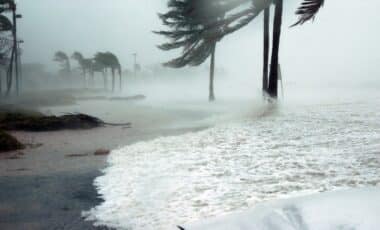
In addition to rain and flooding threats, coastal regions from Byron Bay through to Sydney, including the Hunter and Mid North Coast, face hazardous surf conditions. A separate alert has been issued warning of dangerous surf expected on Tuesday, which poses risks to swimmers, surfers, and boaters.
Authorities have recommended that people avoid entering the water during this period unless absolutely necessary. Boaters are urged to reconsider or delay planned voyages unless already at sea, given the forecasted rough sea state and strong currents. This advisory aims to reduce accidents and ensure public safety during the ongoing severe weather event.

A hazardous surf warning has been issued for the Byron Coast, Coffs Coast, Macquarie Coast, Hunter Coast and Sydney Coast for Tuesday. Image Credit: NCA NewsWire / Max Mason-Hubers