A powerful winter system is set to bring heavy snowfall and strong winds across parts of the western United States. Forecasters warn that some mountainous regions could receive up to 18 inches of snow, with travel conditions expected to deteriorate rapidly.
The National Weather Service (NWS) has issued winter storm warnings and advisories across Washington, Alaska, Montana, and Oregon. According to the NWS, the combination of heavy snowfall, gusty winds, and reduced visibility could create hazardous conditions on roads and in exposed mountain areas through early next week.
Winter storms of this scale are not unusual in early March, yet meteorologists stress that the intensity of snowfall in several high-elevation regions may disrupt travel and outdoor activity. Local authorities are advising residents and travelers to prepare for difficult driving conditions and potential delays.
Heavy Snowfall Forecast across Washington’s Cascade Mountains
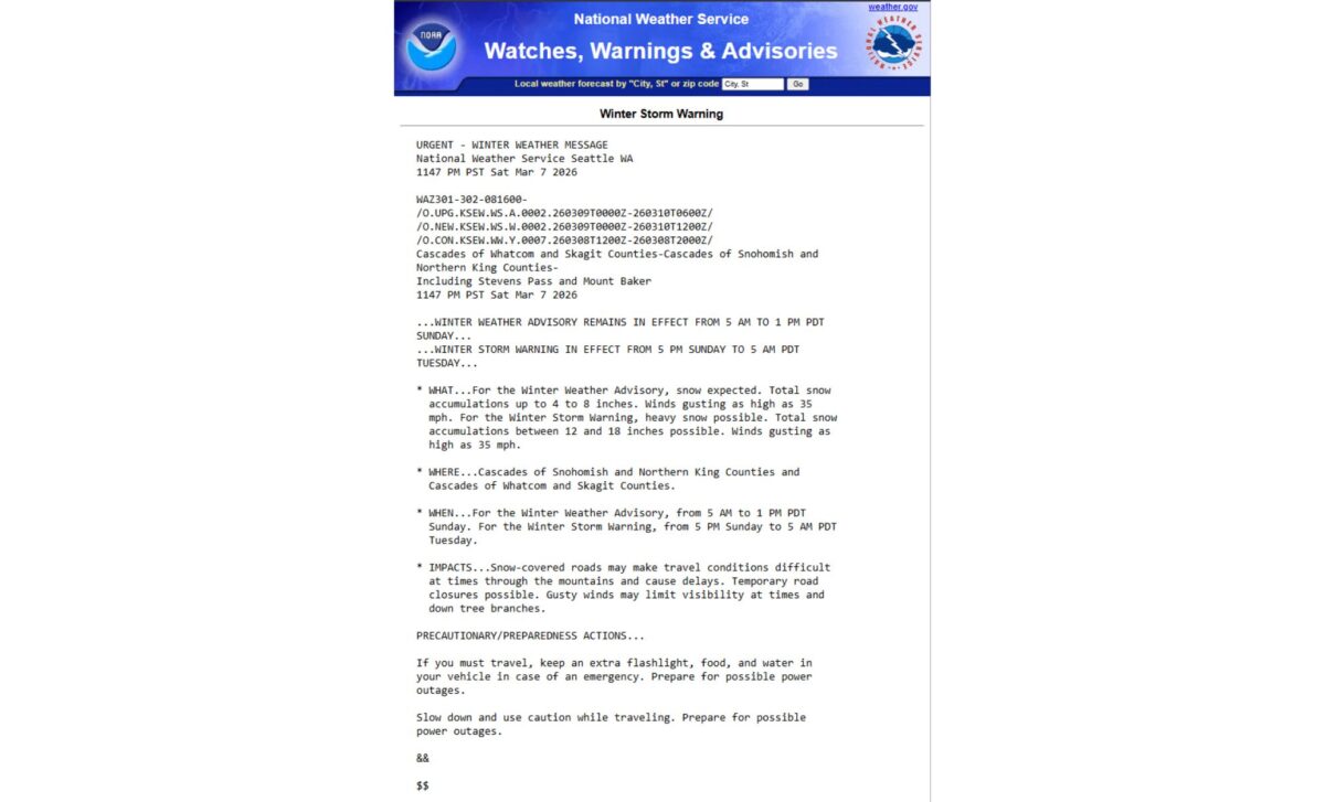
Washington State is expected to see some of the most significant impacts from the approaching system, particularly in the Cascade mountain range. According to the National Weather Service, areas within the Cascades of Snohomish and Whatcom counties, along with northern King and Skagit counties, could receive between 12 and 18 inches of snow beginning Sunday and continuing through Tuesday.
Wind gusts around 35 mph are also forecast across these regions, which may produce periods of blowing snow and reduced visibility, especially overnight Sunday into Monday. Mountain passes could experience particularly challenging conditions as snowfall accumulates.
Some locations may receive even heavier totals. According to the National Weather Service, areas such as Holden Village and Stevens Pass could see snowfall approaching two feet. Further south in the Cascades of Pierce and Lewis counties, as well as southern King County, snowfall totals between 6 and 10 inches are expected from Monday through Tuesday.
Other portions of the state are also under advisories. The South Washington Cascades could receive up to 12 inches of snow accompanied by winds reaching 35 mph. Meanwhile, the upper slopes of the eastern Cascades crest may see between 8 and 14 inches of snow along with wind gusts up to 45 mph through Tuesday afternoon.
Snow, Wind, and Reduced Visibility Expected across Alaska, Montana, and Oregon
Several regions in Alaska are also facing challenging winter conditions as snow showers and strong winds move across coastal and inland areas. According to the National Weather Service, parts of Glacier Bay, eastern Chichagof Island, the Cape Fairweather to Lisianski Strait region, and the city and borough of Juneau could receive up to four inches of additional snowfall by early Sunday morning.
On Prince of Wales Island, snowfall totals may reach five inches, with heavier accumulations possible in higher elevations such as those near Hollis Road. Wind-driven snow is expected along portions of Alaska’s western coastline as well. Areas along the Yukon Delta Coast have been warned that winds up to 40 mph may reduce visibility to less than half a mile at times.
Similar conditions are forecast for the Kuskokwim Delta Coast and Nunivak Island, where wind gusts could reach 45 mph, particularly affecting communities north of Kipnuk and around Toksook Bay. According to the National Weather Service, the central, northern, and southern Alaska Peninsulas may also experience snowfall totals up to five inches along with winds approaching 50 mph, making travel very difficult.
Further south, southwestern Phillips County in Montana could see between one and three inches of snow beginning Sunday evening. The North Oregon Cascades are expected to receive between four and ten inches of snow accompanied by winds around 40 mph through Monday and Tuesday. According to the National Weather Service, these conditions could make roads, bridges, and overpasses especially slippery, posing additional hazards for drivers.