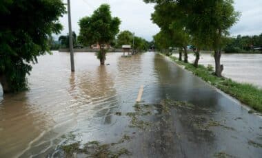
Heavy rain and the possibility of flash floods are affecting several regions in the United States. The National Weather Service (NWS) has issued alerts for these severe conditions, which have the potential to disrupt daily life.
According to a report from Newsweek, the NWS highlighted a significant weather threat across multiple states, with the risk of flash flooding and rain accumulations reaching up to 5 inches in some areas. The forecast, released on Monday afternoon, shows that these conditions could change quickly, urging residents to stay alert. Here’s what you need to know about the current weather threat and its potential impact.
Heavy Rain and Flash Flood Risks Across Seven States
According to the NWS Weather Prediction Center, the forecast for Monday warned that heavy rain and the risk of flash flooding would affect parts of the Lower Mississippi Valley, Mid-South, and Lower Ohio Valley, including southern Indiana, southeastern Illinois, western Kentucky, western Tennessee, far southeastern Missouri, northeastern Arkansas, and far northwestern Mississippi.
The NWS specifically issued a “Slight Risk” (Level 2 out of 4) of excessive rainfall for these areas. This means that there’s a moderate chance of flash flooding occurring due to the rain’s intensity and the region’s vulnerability to rapid water accumulation. The risk of rain and flooding extends to Kentucky on Tuesday, where heavier rainfall is expected to continue.
As of 3 p.m. ET on Monday, a flood advisory had already been issued for parts of eastern Arkansas, with no widespread flood warnings yet in place. However, the forecast indicates that the threat could grow stronger in the coming hours. Areas could receive 3 to 5 inches of rain (about 7.5 to 12.5 cm), potentially triggering localized flooding in regions with poor drainage or near rivers and streams. This kind of weather can escalate quickly, and it’s crucial that residents stay alert and follow local weather advisories.

Why Heavy Rain and Flash Flooding Are Dangerous
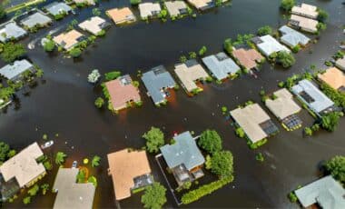
Flash floods are particularly dangerous because they can develop very quickly, often within a matter of minutes to hours after heavy rainfall. The NWS notes that, following extreme heat, flooding is the second leading cause of weather-related deaths in the U.S.
When rain falls in large quantities over a short period, water can overwhelm drainage systems and flood streets, homes, and businesses. Rivers and streams, which are already swollen with rainwater, can rise rapidly and cause extensive damage.
The forecast for Monday specifically mentions that moisture from the Gulf of Mexico is expected to stream northward and pool near a weather front, leading to a significant concentration of rain in the affected regions. In fact, the NWS stated that “areas of 3 to 5 inches of rain are possible” in parts of the Mid-South and Lower Ohio Valley, which increases the likelihood of flash floods.
This phenomenon is a critical issue for the region, as some areas may not be able to drain rainwater fast enough, resulting in dangerous conditions for those in low-lying or flood-prone areas.
What’s Next? The Threat Shifts Eastward
Looking ahead, the NWS forecasts that the threat of thunderstorms and heavy rain will shift eastward over the next few days. By Wednesday, the risk of flash floods is expected to move toward the Eastern Seaboard, though the threat of heavy rainfall will likely diminish after Tuesday. As the storms progress, regions including the Great Lakes, Northeast, and Mid-Atlantic are also likely to experience rain, but not to the same intensity as further south.
In particular, Kentucky and surrounding areas will see a continuation of scattered thunderstorms on Tuesday. The NWS office in Paducah, Kentucky, warned of “heavy rainfall and isolated flooding” throughout the day, with “training storms” expected to cause localized flooding, especially during the morning and early afternoon hours. This refers to storms that move over the same area multiple times, increasing the chance of significant rainfall accumulation.