The UK is bracing for a cold front like no other as snow, ice, and freezing temperatures are set to dominate the weather forecasts for December. According to the Met Office, the first major snowfalls could occur as early as 13 December, bringing intense snow showers and a significant chill, with temperatures expected to plunge below -5 °C in some areas. Here’s everything you need to know about when and where snow will strike, and the potential disruptions it will cause.
Snow Expected to Hit the UK from 13 December
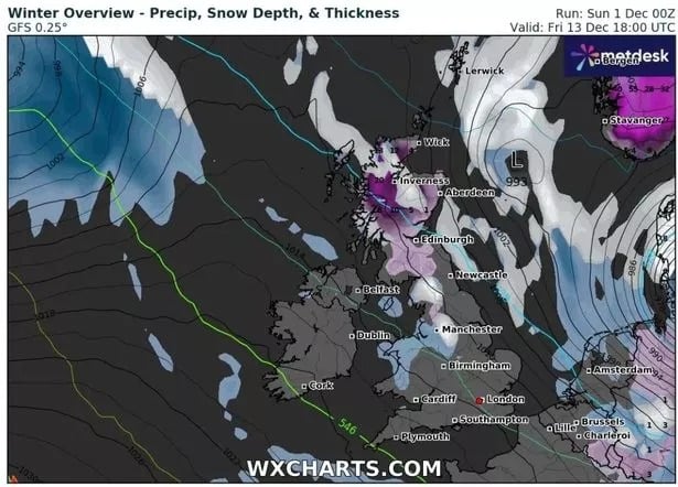
The latest weather maps show that the cold weather will strike the UK from 13 December, with widespread snow expected across large parts of the country. Some areas in Scotland, particularly the Highlands, and parts of Northern England, could see snowfall accumulations of up to 8 inches (20.32 cm), especially in higher ground. This severe weather front will likely cause disruptions to travel and delays across the affected regions.
WXCharts, a popular weather tracking tool, predicts that the north-west and north-east of England, as well as Wales, will be the first to experience this icy onslaught. Southern England may remain relatively mild, but still expect a significant drop in temperatures in the days leading up to Christmas. In addition, the UK could see strong winds alongside the snow, exacerbating the already treacherous travel conditions.
Conditions to Intensify After 13 December
According to the Met Office, from 13 December onwards, temperatures will begin to dip below freezing, with the potential for ice and snow showers continuing through Christmas week. The north of the UK, including parts of Scotland and Northern Ireland, will see the worst conditions, with some mountainous regions in Scotland receiving up to 10 cm of snow. Rain will also become more prevalent across the west, turning into snow as temperatures fall.
In areas like Cumbria, Northumberland, and Yorkshire, snow showers will likely start by the morning of 13 December, intensifying in the afternoon and reaching their peak in the midday hours. Many other regions in South East England could also experience light snow by the evening.
Here’s a look at what’s in store weather wise for the week ahead 👇 pic.twitter.com/lKE9dV1bPv
— Met Office (@metoffice) December 1, 2024
The Big Day: December 17th
A significant weather event is expected on 17 December, when heavy snow will blanket parts of Northern England and Scotland, with 3 cm of snow per hour forecasted. This intense snow will likely begin around 6 AM and continue through the morning, causing substantial disruptions to transport.
In Newcastle, Durham, and other northern areas, snow will rapidly cover roads, creating hazardous conditions for morning commuters. By midday, the snow should ease, but icy conditions will persist, affecting roads well into the evening.
Snow and Ice Expected to Continue Throughout Christmas Week
By mid-December, The Mirror reports that snow and freezing temperatures will start to dominate, with frost settling on the ground overnight. Snowfall could intensify around 18 December, causing further travel disruptions in Scotland, Wales, and Northern England. For those heading southwards, the south-east will begin to feel the chill, with snow flurries expected across areas like Kent and Sussex.
The Met Office has also warned that winter weather could continue through the Christmas period, with sub-zero temperatures and ice storms impacting much of the country. The Christmas weekend itself could see temperatures dipping further, especially in Scotland, where the Highlands are likely to experience the most severe snow conditions.
Long-Term Outlook for December: Snow and Cold Weather Persist
Beyond the initial wave of snow in mid-December, the Met Office suggests that the period between 16 and 30 December will be marked by alternating bouts of snow, ice, and freezing fog. In addition to snow, strong winds and rain showers will bring more disruptions to transport systems across the north-west, with icy roads in highland regions such as the Pennines and the Lake District.
Southern England will see fewer snowstorms but will still experience frosty mornings and foggy conditions throughout the month. The north, on the other hand, could see snow continuing in the higher altitudes, making travel difficult and risky, particularly for those attempting to move between cities or head to rural areas for holiday festivities.
Disruptions to Travel and Daily Life
With the onset of snow across the UK, travel disruption is likely to be on the increase. Flights, trains, and bus services will likely be affected by snow drifts, delays, and cancellations, particularly in northern and western regions. The Mirror also highlighted concerns over power outages, with high winds and heavy snow putting pressure on electricity grids.


