The UK is bracing for 30 hours of intense wintry weather, with snow expected to blanket several regions starting from Saturday, 21 December. As December progresses, temperatures are forecast to drop significantly, bringing widespread disruption.
Initial Areas Affected by Snowfall
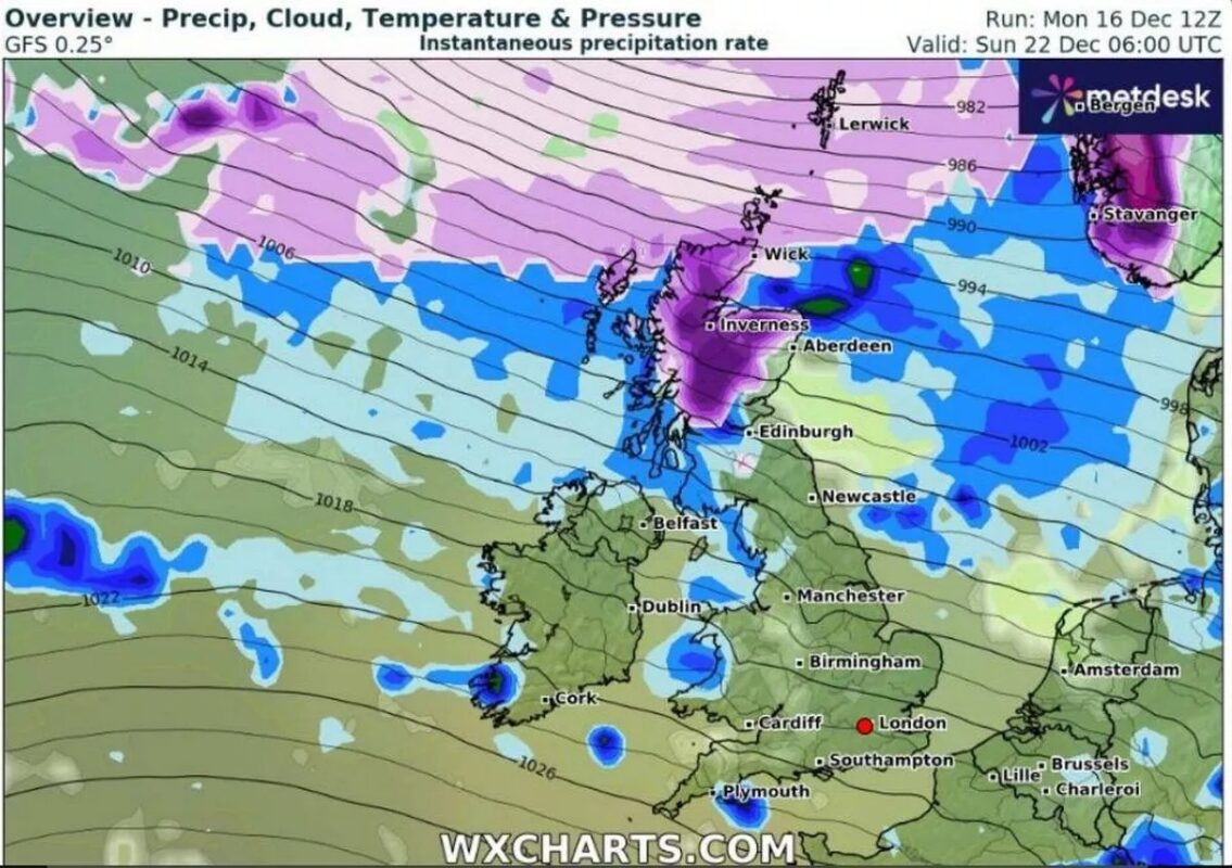
According to WXCharts, which utilises data from Met Desk, Scotland will be the first to feel the impact, with significant snowfall expected on Saturday. This will be followed by the Midlands and North East England by midday, with Manchester and parts of Wales also likely to experience deteriorating conditions. Weather maps highlight a sharp decline, represented by a purple hue on forecast charts.
The key snowfall timeline includes:
- Saturday, 21 December:
- Scotland: significant accumulations expected.
- Midlands and North East England: snowfall predicted by midday.
- Manchester and Wales: challenging wintry conditions expected.
- Sunday, 22 December:
- Potential for up to 10cm of snow in certain areas.
- Continued wintry conditions with snowfall extending into the evening.

Snow Accumulation and Extended Cold Weather
By Sunday morning, some regions may see up to 10cm of snow, with flurries persisting into the evening. According to Netweather TV, the latter half of December will be dominated by unsettled conditions and fluctuating temperatures.
Their forecast notes: “High pressure is expected to shift south and west, allowing a polar maritime north-westerly airflow to take hold, bringing colder, wetter conditions.” While southern areas might enjoy a mild, dry start to the week, unsettled conditions are expected to spread nationwide, delivering rain and snow showers, particularly in northern regions.
Temperatures are anticipated to hover around seasonal averages, with occasional mild spells interspersed with sharp cold snaps. Snowfall is likely to initially affect higher ground in the north, though lower-lying areas may also experience snow at times.
A Brief Mild Spell Before Christmas
Before the cold snap intensifies, temperatures may briefly rise to 14°C midweek, driven by a low-pressure system drawing in warmer air. However, this will also bring rain and cloud cover. By the end of the week, temperatures are expected to plunge sharply.
A Snowy Christmas Forecast
Looking ahead to Christmas Day (25 December), snow is forecast for Scotland, the north of England, and parts of Wales. These wintry conditions are expected to persist for at least two days after Christmas, potentially extending into the weekend.
| Region | Christmas Day (25 December) Forecast | Post-Christmas (26-27 December) |
|---|---|---|
| Central Scotland | Moderate snowfall | Snow depths up to 12cm |
| Pennines | Likely snowfall | Accumulation of up to 14cm |
| Northern England | Intermittent snow | Ongoing wintry conditions |
Places at higher altitudes or those that often get heavy snow are likely to face the most problems. Authorities are asking everyone to stay alert to deal with possible travel delays and tough weather conditions.


