The weekend begins with a series of weather conditions sweeping across the UK, including rain, sleet and snow. This atmospheric phenomenon is the result of a persistent low pressure system that has become entrenched over the region.
A Challenging Weekend Weather Outlook
The weather pattern at present is characterised by a jet stream that plunges southwards in the west and northwards in the east. This has allowed the prolonged presence of low pressure over the UK.
However, over the weekend, the jet stream will shift, allowing milder air to enter the country, although this will be accompanied by wet weather, particularly in the western regions.
Weekend Weather Forecast Highlights
Today’s Forecast
- England and Wales : A mixture of rain, sleet and snow can be expected as we move northwards. While higher ground could see accumulations of snow, lower areas could see slushy conditions.
- Southern regions : Clearer skies after a cool start throughout the day, with persistent snow on the higher ground.
- Northern Ireland : Sunny skies and showers, with wintry conditions at high altitudes and hail possible at lower altitudes.
- Scotland : Generally brighter skies, although the far north may experience wet and windy weather. Temperatures remain cold, ranging from 4 to 9 degrees Celsius.
Transition Towards the Evening
Later this evening, heavy showers could persist in the far south-east, while precipitation continues to move northwards and westwards across Northern Ireland and Scotland.
Clearing skies over England and Wales will make way for light winds, encouraging the formation of dense blankets of fog and freezing patches, especially in central and southeastern regions.
Outbreaks of rain, sleet and hills snow across northern and western areas this evening 🌧️
Clearing skies further south and east allowing temperatures to tumble 🧤 pic.twitter.com/9IhEWhEpDa
— Met Office (@metoffice) March 2, 2024
Weather Outlook for Sunday
- Morning Conditions : Sheets of fog and icy stretches may cause travel problems, particularly in the central and south-eastern regions. However, these conditions should dissipate as the day progresses.
- Daytime Weather : As the low-pressure system begins to weaken, many areas will experience drier conditions. The western regions could see occasional showers, while the east coast could see thicker cloud cover, keeping the atmosphere cool.
- Temperature : While northern areas may experience breezy conditions, most areas will experience light winds. Southern regions will enjoy slightly higher temperatures and more sunshine.
England and Wales Have Had Their Warmest February on Record
February has been very warm in England and Wales this year! According to the Met Office, it was the warmest February on record. It was also quite mild and wet.
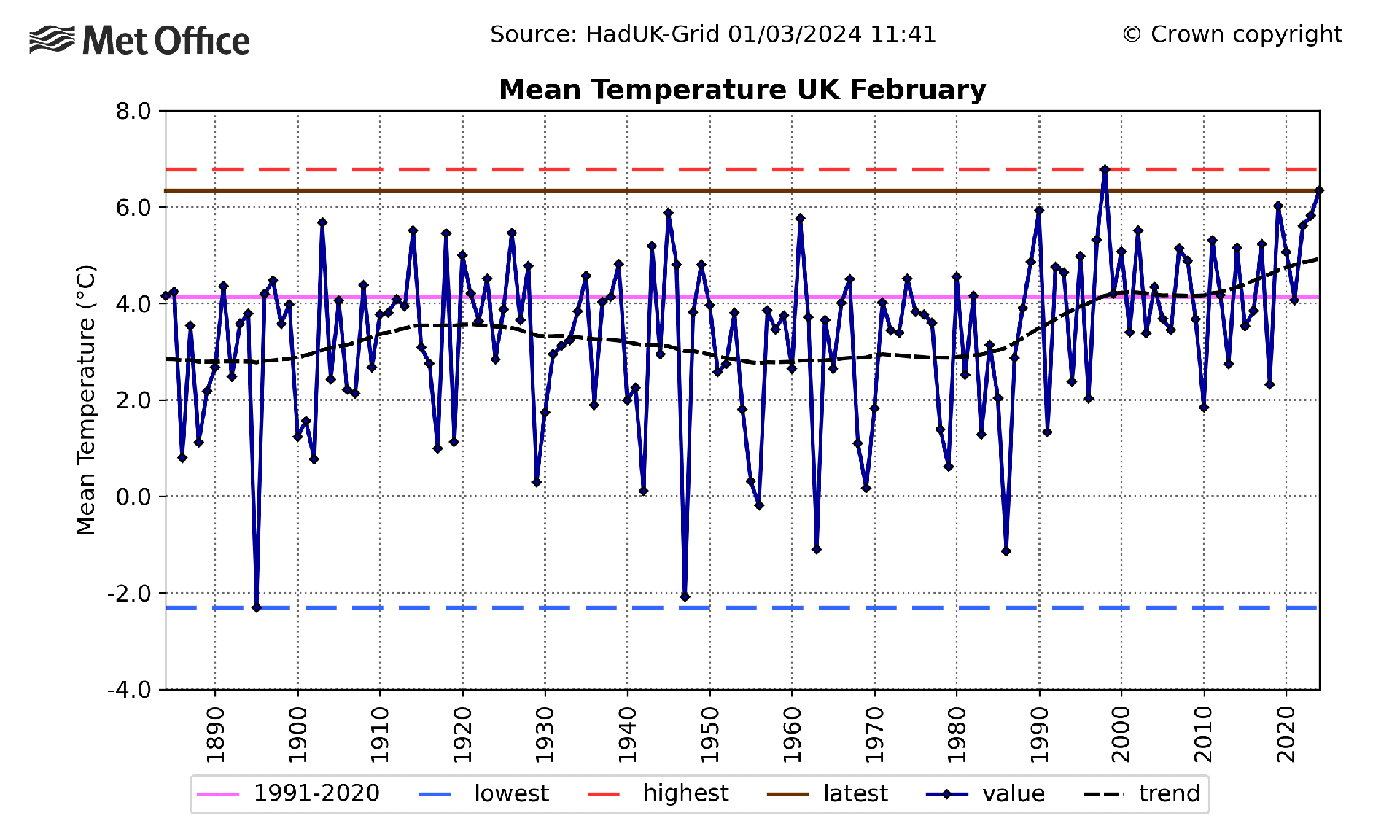
In England, the average temperature for February 2024 was 7.5°C. It was the warmest February on record, beating even 1990, when it was 7.0°C. Wales was also warm, with an average of 6.9°C, just a little higher than the old record of 6.8°C set in 1998.
The whole of the UK felt the heat, with an average temperature of 6.3°C. It’s the second-warmest February on record, although it didn’t quite beat the 1998 record of 6.8°C. The UK’s top 10 warmest Februaries now include 2024, 2023, 2022 and 2019.
Down south, it was really toasty. The southern half of the UK saw temperatures more than 3°C above what’s normal for February. Many counties in southern England had their warmest February on record. Even in the north, it was warmer than usual in many places.


